Approximate Location Map
Large Map »
Latitude: 51.7522 / 51°45'7"N
Longitude: -1.2603 / 1°15'37"W
OS Eastings: 451159
OS Northings: 206201
OS Grid: SP511062
Mapcode National: GBR 8Z4.075
Mapcode Global: VHCXV.37L3
Plus Code: 9C3WQP2Q+VV
Entry Name: College of Further Education
Listing Date: 28 June 1972
Grade: II
Source: Historic England
Source ID: 1047198
English Heritage Legacy ID: 245678
ID on this website: 101047198
Location: Oxford, Oxfordshire, OX1
County: Oxfordshire
District: Oxford
Electoral Ward/Division: Carfax
Parish: Non Civil Parish
Built-Up Area: Oxford
Traditional County: Oxfordshire
Lieutenancy Area (Ceremonial County): Oxfordshire
Church of England Parish: Oxford St Ebbe with Holy Trinity and St Peter le Bailey
Church of England Diocese: Oxford
Tagged with: Building Academic hall of the University of Oxford
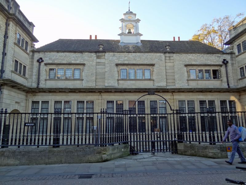
NEW INN HALL STREET
1.
1845
(West Side)
College of Further
Education
SP 5106 SW 8/778
II
2.
1901. By Leonard Stokes. Half-H shaped with wings projecting towards the
street; thus the frontage reads 1.3.1. Stone faced red brick. Quoins.
The wings have doors on the ground floor with fanlights over, and rusticated
architraves; above are 3-light mullioned windows. Parapet. The centre section
has on the ground floor 9 2-light mullion and transom windows set so close
as to be almost one; above are 3 4-light mullioned windows. Parapet with
stone roof, wooden bell cupola. (See also George Street).
Listing NGR: SP5115906201
External links are from the relevant listing authority and, where applicable, Wikidata. Wikidata IDs may be related buildings as well as this specific building. If you want to add or update a link, you will need to do so by editing the Wikidata entry.


Other nearby listed buildings
