Approximate Location Map
Large Map »
Latitude: 51.7768 / 51°46'36"N
Longitude: -1.1626 / 1°9'45"W
OS Eastings: 457873
OS Northings: 209012
OS Grid: SP578090
Mapcode National: GBR 8YW.DXD
Mapcode Global: VHCXP.SLRR
Plus Code: 9C3WQRGP+PX
Entry Name: The Star Inn Public House
Listing Date: 5 June 1985
Grade: II
Source: Historic England
Source ID: 1047577
English Heritage Legacy ID: 246686
Also known as: Star Inn
Star Inn, Oxford
ID on this website: 101047577
Location: Stanton St John, South Oxfordshire, OX33
County: Oxfordshire
District: South Oxfordshire
Civil Parish: Stanton St. John
Built-Up Area: Stanton St John
Traditional County: Oxfordshire
Lieutenancy Area (Ceremonial County): Oxfordshire
Church of England Parish: Stanton St John
Church of England Diocese: Oxford
Tagged with: Pub
SP50NE
5/166
STANTON ST. JOHN
MIDDLE ROAD
(West side)
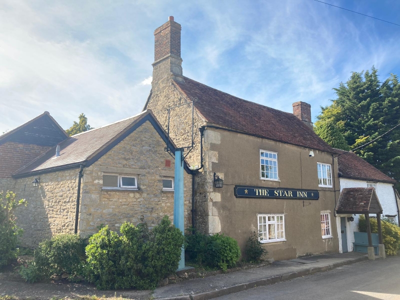
The Star Inn Public House
GV
II
Public house. 1723 on datestone; partly late C17, Limestone rubble, partly
rendered, with squared quoins and timber lintels; old plain-tile roof with brick
and stone stacks. Lobby-entry plan, extended, 2 storeys, 3-window front has
taller 2-bay rendered range, to left, with casements of 2 and 3 lights. Entrance
immediately to right, has single-panel door and a large old tiled canopy on
bracketed posts. 3-light casements, to right, at ground and first floors with
further C20 casement to extreme right. Roof has a tall rendered-stone and brick
stack in line with doorway, and another on the left gable with a stone base
ornamented with projecting weatherings and on oval recessed panel inscribed
"A/IG/1723". Later rubble and brick ranges to left, returning to rear. Interior:
Stair with early C18 turned balusters
Listing NGR: SP5787309012
External links are from the relevant listing authority and, where applicable, Wikidata. Wikidata IDs may be related buildings as well as this specific building. If you want to add or update a link, you will need to do so by editing the Wikidata entry.


Other nearby listed buildings
