Approximate Location Map
Large Map »
Latitude: 51.7787 / 51°46'43"N
Longitude: -1.163 / 1°9'46"W
OS Eastings: 457837
OS Northings: 209224
OS Grid: SP578092
Mapcode National: GBR 8YW.DSF
Mapcode Global: VHCXP.SKH9
Plus Code: 9C3WQRHP+FQ
Entry Name: The Old Parsonage
Listing Date: 24 May 1999
Grade: II
Source: Historic England
Source ID: 1387282
English Heritage Legacy ID: 475220
ID on this website: 101387282
Location: Stanton St John, South Oxfordshire, OX33
County: Oxfordshire
District: South Oxfordshire
Civil Parish: Stanton St. John
Built-Up Area: Stanton St John
Traditional County: Oxfordshire
Lieutenancy Area (Ceremonial County): Oxfordshire
Church of England Parish: Stanton St John
Church of England Diocese: Oxford
Tagged with: Clergy house
SP50NE STANTON ST JOHN MIDDLE ROAD
415/5/10001 The Old Parsonage
GV II
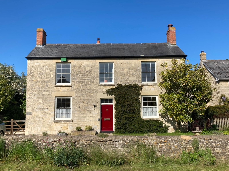
House. Circa 1830-45; extended later C19. Dressed limestone. Slate roof with gabled ends. Brick gable-end stacks.
PLAN: 2-room plan with central entrance hall and with wing to rear left; later in C19 a single storey wing was built at the back and an addition was built in the rear angle.
EXTERIOR: 2 storeys. Symmetrical 3-bay SW front with 12-pane sashes and central doorway with rectangular overflight and panelled door. Two storey wing at rear with sash windows on SE side and later C19 single-storey wing on the gable end, and a late C19 addition in the angle with the main range.
Included as a good and complete example of an early C19 house.
Listing NGR: SP5783709224
External links are from the relevant listing authority and, where applicable, Wikidata. Wikidata IDs may be related buildings as well as this specific building. If you want to add or update a link, you will need to do so by editing the Wikidata entry.


Other nearby listed buildings
