Approximate Location Map
Large Map »
Latitude: 51.6806 / 51°40'50"N
Longitude: -1.4226 / 1°25'21"W
OS Eastings: 440014
OS Northings: 198143
OS Grid: SU400981
Mapcode National: GBR 6X1.M4D
Mapcode Global: VHC0P.908Y
Plus Code: 9C3WMHJG+7W
Entry Name: Southmoor Cottage
Listing Date: 6 July 1987
Grade: II
Source: Historic England
Source ID: 1048379
English Heritage Legacy ID: 249596
ID on this website: 101048379
Location: Kingston Bagpuize, Vale of White Horse, Oxfordshire, OX13
County: Oxfordshire
District: Vale of White Horse
Civil Parish: Kingston Bagpuize with Southmoor
Built-Up Area: Kingston Bagpuize
Traditional County: Berkshire
Lieutenancy Area (Ceremonial County): Oxfordshire
Church of England Parish: Kingston Bagpuize with Southmoor
Church of England Diocese: Oxford
Tagged with: Cottage Thatched cottage
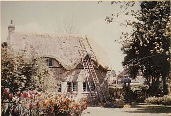
KINGSTON BAGPUIZE WITH SOUTHMOOR FARINGDON ROAD
SU4098 (North side)
Southmoor
11/96 Southmoor Cottage
- II
Two dwellings, now house. Early C18. Colourwashed limestone rubble; half-hipped
thatch roof; brick gable end stack to left. 2-unit plan. One storey and attic;
2-window range. Timber lintel over C20 windows, which include 2 central blocked
doorways: two C18 three-light leaded dormer casements. C18 two-light leaded
dormer casement to rear. Service wing to left, at right angles to front: one
storey, of similar materials with C18 plank door. To rear of this is late C18
bay of coursed limestone rubble with gabled old tile roof: of one storey and
attic, with timber lintels over C18 two-light leaded casements. Former stable
and smithy to rear: of coursed limestone rubble, with C20 weatherboarding to
right side wall, and gabled thatch roof. Interior: front range, formerly of 2
units, has collar-truss roof with butt purlins. Collar-truss in front service
range.
Listing NGR: SU4001498143
External links are from the relevant listing authority and, where applicable, Wikidata. Wikidata IDs may be related buildings as well as this specific building. If you want to add or update a link, you will need to do so by editing the Wikidata entry.


Other nearby listed buildings
