Approximate Location Map
Large Map »
Latitude: 52.6302 / 52°37'48"N
Longitude: 1.3002 / 1°18'0"E
OS Eastings: 623436
OS Northings: 308717
OS Grid: TG234087
Mapcode National: GBR WB1.C3
Mapcode Global: WHMTM.Y49Z
Plus Code: 9F43J8J2+33
Entry Name: 3 and 4, the Close
Listing Date: 26 February 1954
Grade: II*
Source: Historic England
Source ID: 1051334
English Heritage Legacy ID: 228925
ID on this website: 101051334
Location: The Close, Norwich, Norfolk, NR1
County: Norfolk
District: Norwich
Electoral Ward/Division: Thorpe Hamlet
Parish: Non Civil Parish
Built-Up Area: Norwich
Traditional County: Norfolk
Lieutenancy Area (Ceremonial County): Norfolk
Tagged with: Building
TG 2308 NW THE CLOSE
16/177
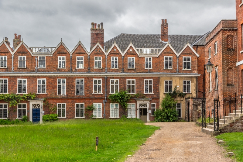
26.2.54 Nos. 3 and 4
GV II*
On site of the former Almoners Barn, now offices. C17 with C19 additions.
Red brick, 2 right-hand bays rendered. Pantile roof. 3-storeys 11 bays.
C18 doors in 3rd bay from each end with plain pilasters, fluted architrave
and flat hood. Rectangular fanlights. Mullion and transom windows throughout.
Brick stringcourse above ground floor. Modillion cornice above 1st floor.
Internally: 2 staircases, turned balusters. Panelled rooms on ground and
first-floors.
Listing NGR: TG2343608716
External links are from the relevant listing authority and, where applicable, Wikidata. Wikidata IDs may be related buildings as well as this specific building. If you want to add or update a link, you will need to do so by editing the Wikidata entry.


Other nearby listed buildings
