Latitude: 51.8822 / 51°52'56"N
Longitude: -1.5953 / 1°35'43"W
OS Eastings: 427950
OS Northings: 220486
OS Grid: SP279204
Mapcode National: GBR 5RY.ZDM
Mapcode Global: VHBZF.9YGG
Plus Code: 9C3WVCJ3+VV
Entry Name: Lyneham Farmhouse and Attached Farmbuildings
Listing Date: 15 May 1989
Grade: II
Source: Historic England
Source ID: 1053307
English Heritage Legacy ID: 254064
ID on this website: 101053307
Location: Lyneham, West Oxfordshire, OX7
County: Oxfordshire
District: West Oxfordshire
Civil Parish: Lyneham
Traditional County: Oxfordshire
Lieutenancy Area (Ceremonial County): Oxfordshire
Church of England Parish: Milton-under-Wychwood
Church of England Diocese: Oxford
Tagged with: Farmhouse
LYNEHAM HIGH STREET SP 22 SE (north side)
7/166 Lyneham Farmhouse and attached farmbuildings
GV II
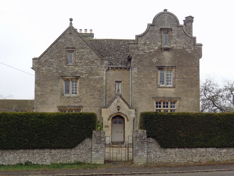
Farmhouse and attached model farmbuildings. Farmhouse. Dated 1843; minor later additions and alterations. Roughly coursed limestone rubble; stone slate roof with moulded coped verges to gables and hipped to rear; corbelled eaves cornice to short centre range to front. Main range only one room deep. 2 storeys and attic. Projecting shaped gable to right has 3-light mullioned and transomed ovolo-moulded window to ground floor, similar mullioned window of 2 lights to first floor and slightly projecting window surround housing narrow rectangular window to attic. Short centre range has recessed narrow rectangular window on first floor directly above gabled porch with datestone "AD/1843", ball finial to apex and hoodmould to outer Tudor arch; 6-panel inner door (upper panels now glazed) with Tudor-arched wreathed and radiating fanlight. Slightly projecting gable with ball finial to left has similar windows to right gable, except they are cavetto-moulded and window surround to attic does not project. Canted bay window to left return and prominent ridge stack. Right gable has external lateral stack to right, having twin diagonal shafts with moulded capping. Cellar beneath. All windows have either cast-iron or leaded lights. Prominent external stack to back wall on left with contemporary gabled service ranges projecting to rear. Longest of these is linked to west range of farmbuildings which connects with 2-bay cart shelter with central passage-way on north. This is abutted on west side by long barn with segmental-headed plank doors and windows on both floors and 2 lean-to cart entrances (with opposing entrances to south) on north side. Hip-roofed range projecting at right-angles to south towards east end has external lateral stack with tapering shaft. Further to west, also at right-angles to south of barn, are attached cowhouses with short range projecting at right-angles to west. Roofs of farmbuildings mainly have concrete tiles but otherwise buildings are largely unaltered externally. Interior. Large barn has mixture of king posts and raking struts from tie beams to principal rafters to trenched-purlin roof. Loft to 4 west bays and C19 quarry tile floor. gearing for former threshing machine survives to 3 eastern bays but all other machinery gone. [2616]
Listing NGR: SP2795020486
External links are from the relevant listing authority and, where applicable, Wikidata. Wikidata IDs may be related buildings as well as this specific building. If you want to add or update a link, you will need to do so by editing the Wikidata entry.


Other nearby listed buildings