Approximate Location Map
Large Map »
Latitude: 51.8816 / 51°52'53"N
Longitude: -1.596 / 1°35'45"W
OS Eastings: 427905
OS Northings: 220413
OS Grid: SP279204
Mapcode National: GBR 5RY.Z6D
Mapcode Global: VHBZF.9Y3Y
Plus Code: 9C3WVCJ3+JJ
Entry Name: Cart Shelter Approximately 10 Metre West of Isod's Farmhouse and Attached Barns
Listing Date: 15 May 1989
Grade: II
Source: Historic England
Source ID: 1367813
English Heritage Legacy ID: 254067
ID on this website: 101367813
Location: Lyneham, West Oxfordshire, OX7
County: Oxfordshire
District: West Oxfordshire
Civil Parish: Lyneham
Traditional County: Oxfordshire
Lieutenancy Area (Ceremonial County): Oxfordshire
Church of England Parish: Milton-under-Wychwood
Church of England Diocese: Oxford
Tagged with: Carriage house
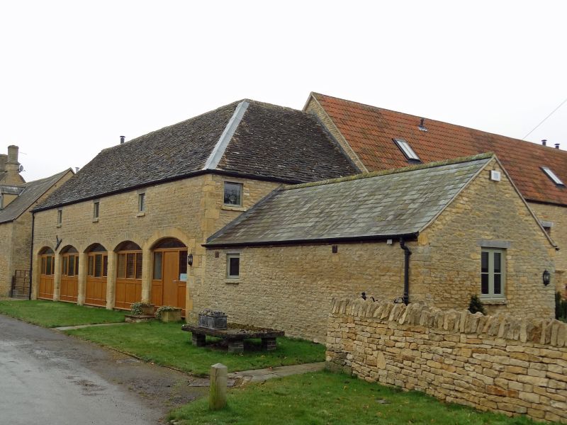
LYNEHAM HIGH STREET
SP22SE (South side)
7/169 Cart shelter approx. 10m W of
Isod's Farmhouse and attached
barns
GV II
Cart shelter. Early C19 with minor later alterations. Roughly coursed limestone
rubble with quoins and dressed stone to arches and piers; stone slate roof,
hipped to right. Open to road in 5 bays (right infilled) with segmental arches.
3 small windows directly below eaves and segmental-arched boarded door to upper
level in left gable end. Occupies a prominent road-side position. Included for
group value.
[2619]
Listing NGR: SP2790520413
External links are from the relevant listing authority and, where applicable, Wikidata. Wikidata IDs may be related buildings as well as this specific building. If you want to add or update a link, you will need to do so by editing the Wikidata entry.


Other nearby listed buildings
