Approximate Location Map
Large Map »
Latitude: 51.1883 / 51°11'17"N
Longitude: -3.2222 / 3°13'19"W
OS Eastings: 314682
OS Northings: 143937
OS Grid: ST146439
Mapcode National: GBR LW.5FHG
Mapcode Global: VH6GR.3DFF
Plus Code: 9C3R5QQH+84
Entry Name: Unknown Chest Tomb, in Churchyard 2 Metres South of Chancel, Church of St Mary
Listing Date: 16 November 1984
Grade: II
Source: Historic England
Source ID: 1057389
English Heritage Legacy ID: 265172
ID on this website: 101057389
Location: St Mary's Church, Kilve, Somerset, TA5
County: Somerset
District: Somerset West and Taunton
Civil Parish: Kilve
Traditional County: Somerset
Lieutenancy Area (Ceremonial County): Somerset
Tagged with: Chest tomb
ST14SW KILVE CP SEA LANE (West Lane)
5/119
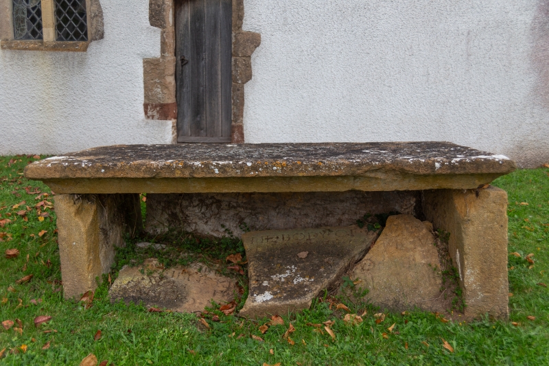
Unknown chest tomb, in churchyard
2 metres South of chancel, Church
of St Mary
-
GV II
Unidentified chest tomb, C17. Sandstone. Flat topped, cavetto moulded cornice sunk and leaning heavily to North, South
side missing. Listed for group value as part of a good collection of C17 chest tombs.
Listing NGR: ST1468243937
External links are from the relevant listing authority and, where applicable, Wikidata. Wikidata IDs may be related buildings as well as this specific building. If you want to add or update a link, you will need to do so by editing the Wikidata entry.


Other nearby listed buildings
