Approximate Location Map
Large Map »
Latitude: 51.1889 / 51°11'20"N
Longitude: -3.2229 / 3°13'22"W
OS Eastings: 314635
OS Northings: 144012
OS Grid: ST146440
Mapcode National: GBR LW.57BV
Mapcode Global: VH6GR.3C1X
Plus Code: 9C3R5QQG+HV
Entry Name: Remains of Chantry, Abutting East Side of Chantry Cottage
Listing Date: 16 November 1984
Grade: II*
Source: Historic England
Source ID: 1345688
English Heritage Legacy ID: 265168
Also known as: Remains of 14th century chantry at Kilve
Chantry
ID on this website: 101345688
Location: Somerset, TA5
County: Somerset
District: Somerset West and Taunton
Civil Parish: Kilve
Traditional County: Somerset
Lieutenancy Area (Ceremonial County): Somerset
Tagged with: Human settlement Ruins Chantry chapel
ST14SW KILVE CP SEA LANE (West side)
5/123 Remains of Chantry, abutting East
side of Chantry Cottage
-
GV II*
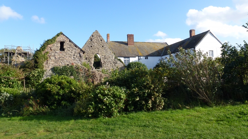
Remains of collegiate dwelling of chantry priests, now ruin. Early C14, later medieval addition. gutted by fire mid
C19. Blue lias random rubble. Plan: gabled block lying North South abutting Priory and Chantry Cottage (qv) is solar
wing to the latter hall, contemporary chapel wing, gabled in South East corner with larger later nedieval gabled
addition in North East corner. Large stepped angle buttresses to wings, North East wing with chamfered plinth and
altered square headed window on East front and square headed opening in gable end. The building is otherwise completely
obscured by ivy and undergrowth at time of survey (August 1983). The college of chantry priests was founded under
license 1329 and disolved late C14. Scheduled Ancient Monument (Somerset County No 480) (There are many early C19
watercolours of the building before the fire in the Local History Library Taunton; photograph in NMR; VCH Somerset, Vol
5 forthcoming).
Listing NGR: ST1463544012
External links are from the relevant listing authority and, where applicable, Wikidata. Wikidata IDs may be related buildings as well as this specific building. If you want to add or update a link, you will need to do so by editing the Wikidata entry.


Other nearby listed buildings
