Approximate Location Map
Large Map »
Latitude: 51.1478 / 51°8'51"N
Longitude: -2.7167 / 2°43'0"W
OS Eastings: 349966
OS Northings: 138967
OS Grid: ST499389
Mapcode National: GBR MK.7X4Y
Mapcode Global: VH8B3.VDNZ
Plus Code: 9C3V47XM+48
Entry Name: 17 and 17B, High Street
Listing Date: 15 March 1974
Grade: II
Source: Historic England
Source ID: 1057924
English Heritage Legacy ID: 265923
ID on this website: 101057924
Location: Glastonbury, Somerset, BA6
County: Somerset
District: Mendip
Civil Parish: Glastonbury
Built-Up Area: Glastonbury
Traditional County: Somerset
Lieutenancy Area (Ceremonial County): Somerset
Tagged with: Building
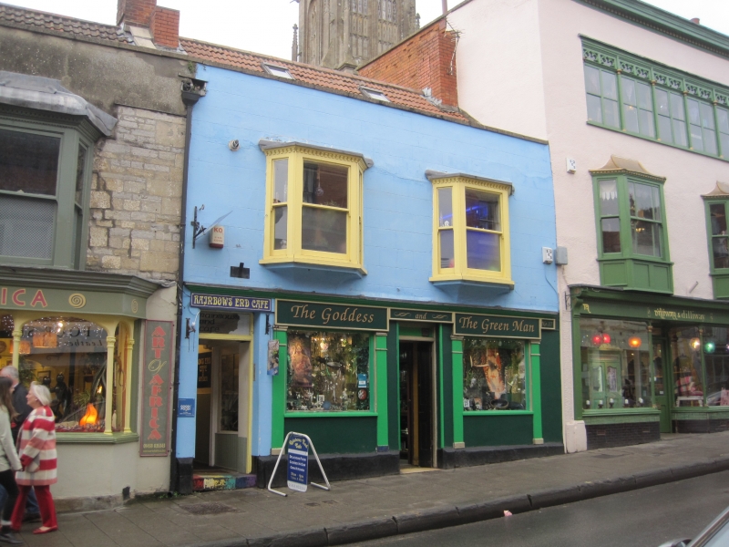
HIGH STREET
1.
1133
(North Side)
Nos 17 and 17b
ST 4938 7/146
II GV
2.
One building. Probably C18, altered later. 2 storeys. Plain cornice and parapet.
Pantile roof. 2 wooden oriels with dentilled eaves to 1st floor. 3-light windows
to each. Sashes, no glazing bars. Moulded cornice over ground floor. 2 modern
1/2-glazed doors and 2 shop-windows with 4 pilasters having moulded capitals.
Nos 15, 17, 17b, 19 form a group.
Listing NGR: ST4996538971
External links are from the relevant listing authority and, where applicable, Wikidata. Wikidata IDs may be related buildings as well as this specific building. If you want to add or update a link, you will need to do so by editing the Wikidata entry.


Other nearby listed buildings
