Approximate Location Map
Large Map »
Latitude: 51.1478 / 51°8'52"N
Longitude: -2.7166 / 2°42'59"W
OS Eastings: 349973
OS Northings: 138969
OS Grid: ST499389
Mapcode National: GBR MK.7X67
Mapcode Global: VH8B3.VDQY
Plus Code: 9C3V47XM+49
Entry Name: 19, High Street
Listing Date: 15 March 1974
Grade: II
Source: Historic England
Source ID: 1167790
English Heritage Legacy ID: 265924
ID on this website: 101167790
Location: Glastonbury, Somerset, BA6
County: Somerset
District: Mendip
Civil Parish: Glastonbury
Built-Up Area: Glastonbury
Traditional County: Somerset
Lieutenancy Area (Ceremonial County): Somerset
Tagged with: Building
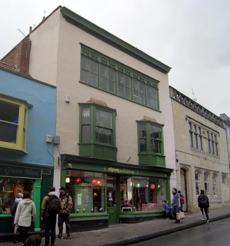
HIGH STREET
1.
1133
(North Side)
No 19
ST 4938 7/147
II GV
2.
Early/mid C19. 3 storeys. Roughcast. Deep cornice with modillions at top of
front. 2nd storey has a continuous band of windows (10 lights) under a single
moulding. Lights have cusped heads, paired between colonettes with moulded capitals.
Casements without glazing bars. 1st floor has 2 wooden splayed bays with coved
lead roofs and dentilled cornices. Aprons under windows, 3-lights to each bay.
Sashes with close-set glazing bars. Large shop-front under dentilled cornice.
Fluted pilasters with volutes to each side. Shop-windows with colonettes and moulded
capitas.
Nos 15, 17, 17b, 19 form a group.
Listing NGR: ST4997138978
External links are from the relevant listing authority and, where applicable, Wikidata. Wikidata IDs may be related buildings as well as this specific building. If you want to add or update a link, you will need to do so by editing the Wikidata entry.


Other nearby listed buildings
