Approximate Location Map
Large Map »
Latitude: 51.5734 / 51°34'24"N
Longitude: -1.2026 / 1°12'9"W
OS Eastings: 455355
OS Northings: 186364
OS Grid: SU553863
Mapcode National: GBR 91B.8RM
Mapcode Global: VHCYN.3QK5
Plus Code: 9C3WHQFW+9W
Entry Name: Wall and Railings to Side and Front of Edlins
Listing Date: 13 January 1986
Grade: II
Source: Historic England
Source ID: 1059276
English Heritage Legacy ID: 247935
ID on this website: 101059276
Location: Aston Upthorpe, South Oxfordshire, OX11
County: Oxfordshire
District: South Oxfordshire
Civil Parish: Aston Upthorpe
Built-Up Area: Aston Tirrold
Traditional County: Berkshire
Lieutenancy Area (Ceremonial County): Oxfordshire
Church of England Parish: Aston Tirrold
Church of England Diocese: Oxford
Tagged with: Wall
SU5586
7/51
ASTON UPTHORPE
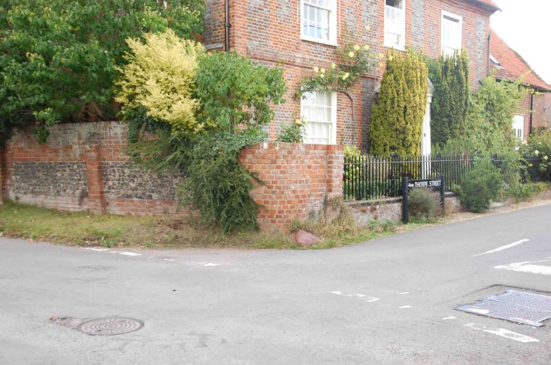
THORPE STREET
(West side)
Wall and railings to side and front of Edlins
GV
II
Wall. C18, with C20 repointing. Flint and brick with brick dressings and angled
brick coping. C19 cast-iron railings with vase-topped main posts. Included for
group value.
Listing NGR: SU5535586364
External links are from the relevant listing authority and, where applicable, Wikidata. Wikidata IDs may be related buildings as well as this specific building. If you want to add or update a link, you will need to do so by editing the Wikidata entry.


Other nearby listed buildings
