Approximate Location Map
Large Map »
Latitude: 51.5216 / 51°31'17"N
Longitude: -1.1388 / 1°8'19"W
OS Eastings: 459849
OS Northings: 180647
OS Grid: SU598806
Mapcode National: GBR 920.DYF
Mapcode Global: VHCZ2.60TW
Plus Code: 9C3WGVC6+JF
Entry Name: Tudor Cottage
Listing Date: 16 August 1985
Grade: II
Source: Historic England
Source ID: 1059553
English Heritage Legacy ID: 247279
ID on this website: 101059553
Location: Goring, South Oxfordshire, RG8
County: Oxfordshire
District: South Oxfordshire
Civil Parish: Goring-on-Thames
Built-Up Area: Goring
Traditional County: Oxfordshire
Lieutenancy Area (Ceremonial County): Oxfordshire
Church of England Parish: Goring
Church of England Diocese: Oxford
Tagged with: Cottage
GORING MANOR ROAD
SU5980 (West side)
Coring-on-Thames
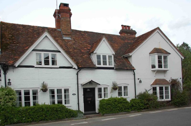
11/62 Tudor Cottage
- II
Cottage. C17 with C19 alterations. Painted brick; plain tile roof; brick ridge
stack to centre. Lobby entry plan. Single storey and attic; 2-window range.
Central plank door. Two 3-light casements to left. Two 2-light casements to
right. Cross-gable to left with 3-light casement. Gabled dormer to right.
interior not inspected. C19 extension to right. 2 storeys; one-window range.
Angled bays with hipped plain tile roofs to ground and first floor.
Listing NGR: SU5984980647
External links are from the relevant listing authority and, where applicable, Wikidata. Wikidata IDs may be related buildings as well as this specific building. If you want to add or update a link, you will need to do so by editing the Wikidata entry.


Other nearby listed buildings
