Approximate Location Map
Large Map »
Latitude: 51.5217 / 51°31'18"N
Longitude: -1.1369 / 1°8'12"W
OS Eastings: 459976
OS Northings: 180660
OS Grid: SU599806
Mapcode National: GBR 920.FCV
Mapcode Global: VHCZ2.70TT
Plus Code: 9C3WGVC7+M6
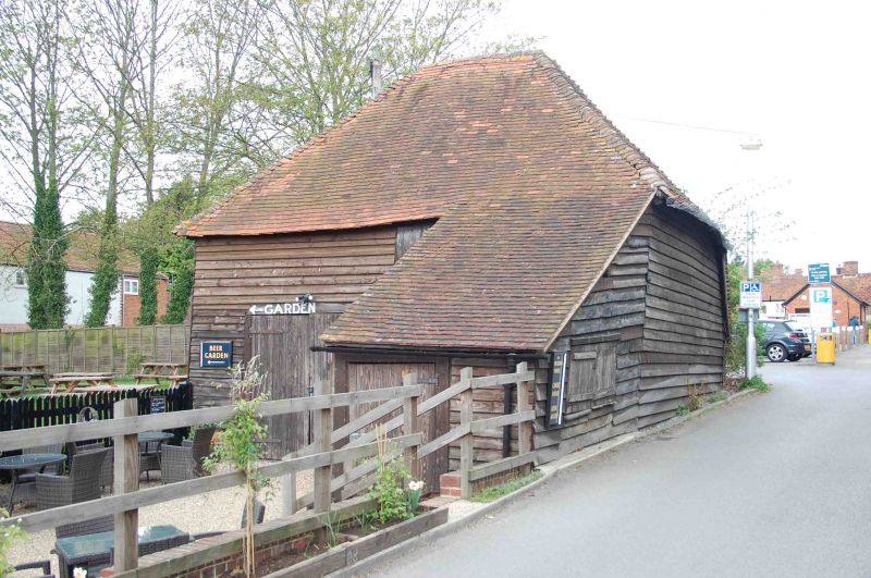
Entry Name: Barn Approximately 5 Metres North of the Catherine Wheel Public House
Listing Date: 16 August 1985
Grade: II
Source: Historic England
Source ID: 1368960
English Heritage Legacy ID: 247287
ID on this website: 101368960
Location: Goring, South Oxfordshire, RG8
County: Oxfordshire
District: South Oxfordshire
Civil Parish: Goring-on-Thames
Built-Up Area: Goring
Traditional County: Oxfordshire
Lieutenancy Area (Ceremonial County): Oxfordshire
Church of England Parish: Goring
Church of England Diocese: Oxford
Tagged with: Barn
GORING STATION R0AD
SU5980 (North side)
Goring-on-Thames
11/70 Barn approx. 5m. N of The
Catherine Wheel Public House
GV II
Barn. Probably early C18. Brick base; timber framing; weatherboarding; plain
tile hipped roof. Double plank door to centre. Interior not inspected. Included
for group value.
Listing NGR: SU5997680660
External links are from the relevant listing authority and, where applicable, Wikidata. Wikidata IDs may be related buildings as well as this specific building. If you want to add or update a link, you will need to do so by editing the Wikidata entry.


Other nearby listed buildings
