Approximate Location Map
Large Map »
Latitude: 52.7639 / 52°45'49"N
Longitude: -1.9364 / 1°56'10"W
OS Eastings: 404391
OS Northings: 318474
OS Grid: SK043184
Mapcode National: GBR 3B6.P8F
Mapcode Global: WHBF3.7S5J
Plus Code: 9C4WQ377+GF
Entry Name: 9, Wolseley Road
Listing Date: 1 May 1951
Last Amended: 5 July 1972
Grade: II
Source: Historic England
Source ID: 1060214
English Heritage Legacy ID: 271273
ID on this website: 101060214
Location: Rugeley, Cannock Chase, Staffordshire, WS15
County: Staffordshire
District: Cannock Chase
Civil Parish: Rugeley
Built-Up Area: Rugeley
Traditional County: Staffordshire
Lieutenancy Area (Ceremonial County): Staffordshire
Church of England Parish: Brereton and Rugeley
Church of England Diocese: Lichfield
Tagged with: Building
1.
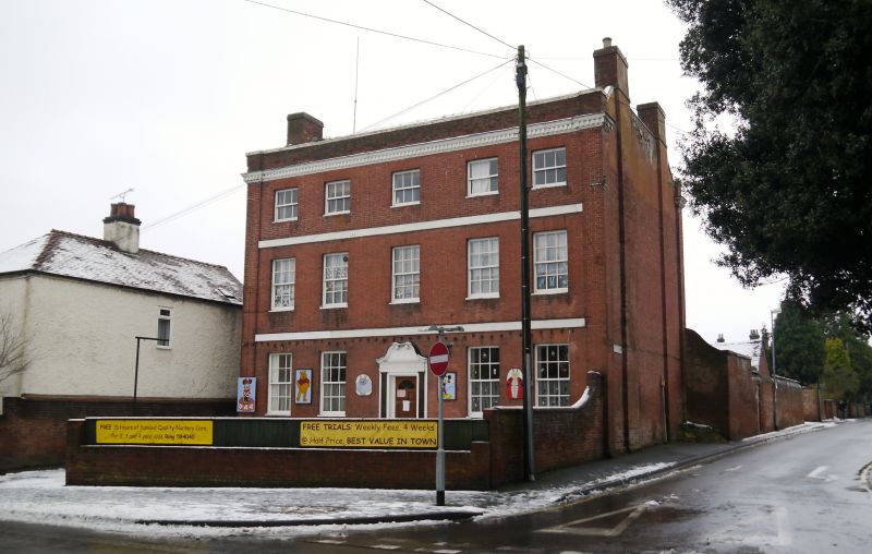
1571 WOLSELEY ROAD
No 9
(formerly listed as
No 37)
SK 0418 1/14 1.5.51.
II
2.
Late C18. Red brick; 3 storeys; 5 sash windows; moulded wood doorcase with
curved voluted pediment; bands; plain pilasters at sides; dentilled wood
eaves; parapet.
Listing NGR: SK0439118474
External links are from the relevant listing authority and, where applicable, Wikidata. Wikidata IDs may be related buildings as well as this specific building. If you want to add or update a link, you will need to do so by editing the Wikidata entry.


Other nearby listed buildings
