Approximate Location Map
Large Map »
Latitude: 51.0734 / 51°4'24"N
Longitude: 1.1488 / 1°8'55"E
OS Eastings: 620683
OS Northings: 135174
OS Grid: TR206351
Mapcode National: GBR V0P.P7Y
Mapcode Global: FRA F698.TN9
Plus Code: 9F3334FX+9G
Entry Name: Sandgate Castle
Listing Date: 5 December 1949
Grade: I
Source: Historic England
Source ID: 1061237
English Heritage Legacy ID: 175279
ID on this website: 101061237
Location: Sandgate, Folkestone and Hythe, Kent, CT20
County: Kent
District: Folkestone and Hythe
Civil Parish: Sandgate
Built-Up Area: Folkestone
Traditional County: Kent
Lieutenancy Area (Ceremonial County): Kent
Tagged with: Castle Fort Device Fort
1.
5281 CASTIE ROAD
(South Side)
SANDGATE
Sandgate Castle
TR 2035 SE 7/20 5.12.49.
GV
2.
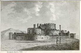
In private ownership. Built in 1539-1540 at the same time and as part of the
same series of defences as Sandown, Deal and Walmer Castles, but altered again
for defence purposes in 1805. It originally comprised a large central tower
surrounded by 3 smaller towers connected with each other by a curtain wall and
covered galleries, with an outer curtain wall and gate-tower on the north and
a rectangular building connecting the latter to the central tower. In 1805 the
tops of the towers were removed (the central tower being converted into a Martello tower) and the materials used to fill up the space between tile inner and outer walls. Most of the outer wall is missing on the south side, presumably destroyed during the 1939-45 war, and modern pill-boxes have been constructed in the place of part of it. AM.
No 2, Sandgate Castle, The Hermitage, York Cottage, Gatepieris to the White Lodge
form a group with Nos 12 to 16 (even) and Gatepiers to Nos 12 to 16 (even). (No 2
and Nos 12 to 16 (even) and Gatepiers to Nos 12 to 16 (even) being buildings of local interest.
Listing NGR: TR2068335173
External links are from the relevant listing authority and, where applicable, Wikidata. Wikidata IDs may be related buildings as well as this specific building. If you want to add or update a link, you will need to do so by editing the Wikidata entry.


Other nearby listed buildings
