Latitude: 54.4193 / 54°25'9"N
Longitude: -3.4313 / 3°25'52"W
OS Eastings: 307222
OS Northings: 503592
OS Grid: NY072035
Mapcode National: GBR 4KGB.XL
Mapcode Global: WH711.859Y
Plus Code: 9C6RCH99+PF
Entry Name: Church of St Mary
Listing Date: 9 March 1967
Grade: I
Source: Historic England
Source ID: 1063710
English Heritage Legacy ID: 76228
ID on this website: 101063710
Location: St Mary's Church, Gosforth, Cumberland, Cumbria, CA20
County: Cumberland
District: Copeland
Civil Parish: Gosforth
Built-Up Area: Gosforth
Traditional County: Cumberland
Lieutenancy Area (Ceremonial County): Cumbria
Church of England Parish: Gosforth St Mary
Church of England Diocese: Carlisle
Tagged with: Church building Norman architecture
SD 0603/0703 (PART) GOSFORTH GOSFORTH
27/30 Church of St Mary
9.3.67 G.V. I
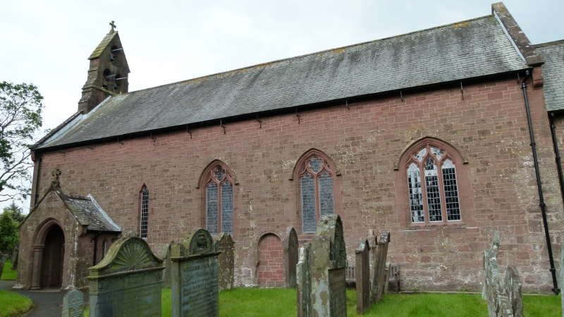
Parish Church. An important site since the C8th. Oldest parts of existing fabric are C12; extensively remodelled and extended prior to 1897 when nave was rebuilt, with north aisle and vestry added, by C.J. Ferguson. Older masonry in south nave wall is coursed blocks, later work in snecked rubble. Graduated slate roofs (chancel lower) with stone ridges, copings, and kneelers; gabled bellcote, dated 1897, corbelled out at west end. Nave with north aisle, chancel, and vestries to north. Gabled C19 porch to south door with original C12 north door surround (now blocked) reset to right. Single-light and traceried multi-light windows (some under hoodmoulds) to nave and chancel. Interior: 4-bay north arcade of pointed arches carried between columns with octagonal capitals. Chancel arch springs from (reset?) C12 carved capitals. A large niche at the east end of the aisle houses 2 richly carved hogback tombstones (found in the foundations of the C12 church); other medieval fragments, including cross-heads and tomb slabs, are incorporated into the jambs of the niche, the spandrels above, and the inner walls of the porch. Small C19 octagonal font at the west end. Externally, on the north side of the chancel, is an early C19 memorial to the Hudlestons, John (a land surveyor, died 1834) and his wife Mary (died 1822): Inscription on slate with coat-of-arms on apron below; fluted pilasters support cornice surmounted by low relief carving of woman with anchor. Graded primarily for the numerous early medieval fragments incorporated into the structure.
Listing NGR: NY0722103590
External links are from the relevant listing authority and, where applicable, Wikidata. Wikidata IDs may be related buildings as well as this specific building. If you want to add or update a link, you will need to do so by editing the Wikidata entry.


Other nearby listed buildings