Latitude: 52.1883 / 52°11'17"N
Longitude: -2.2361 / 2°14'10"W
OS Eastings: 383953
OS Northings: 254477
OS Grid: SO839544
Mapcode National: GBR 1G3.ZCM
Mapcode Global: VH92T.6869
Plus Code: 9C4V5QQ7+8G
Entry Name: 5-17, Bromyard Road
Listing Date: 3 April 1989
Grade: II
Source: Historic England
Source ID: 1063793
English Heritage Legacy ID: 488626
ID on this website: 101063793
Location: St John's, Worcester, Worcestershire, WR2
County: Worcestershire
District: Worcester
Electoral Ward/Division: St John
Parish: Non Civil Parish
Built-Up Area: Worcester
Traditional County: Worcestershire
Lieutenancy Area (Ceremonial County): Worcestershire
Church of England Parish: St John in Bedwardine
Church of England Diocese: Worcester
Tagged with: Building
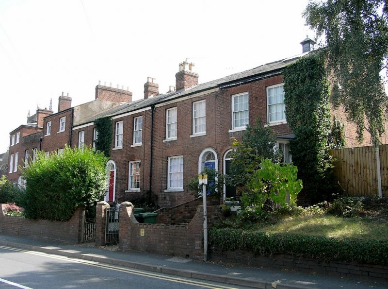
WORCESTER
SO85SW BROMYARD ROAD
620-1/3/143 (South side)
03/04/89 Nos.5-17 (Odd)
GV II
Row of 7 houses. c1830 with later additions and alterations
including C19 and C20 extensions to rear. Red brick with Welsh
slate roof and various brick ridge and rear stacks. Nos 5 and 9
are 3 storeys and basement, otherwise 2 storeys and basement; 14
first-floor windows (2 per house). No.5 has sashes with gauged
brick lintels and on left end a part-glazed door with fanlight.
No.7 has 6/6 sashes and reeded doorcase and door, with canted bay
to right, also with 6/6 and 4/4 sashes. No.9 has 3/6, 6/6 and 8/8
sashes, gauged brick lintel to ground floor, C20 basement window.
Nos 11, 13 and 15 have 6/6 and 8/8 sashes, with gauged brick
lintels to ground floor, and reeded doorcase with fanlights and
5-panel doors. No.17 has similar sashes and doorway but with a
canted bay window to right with 6/6 and 4/4 sashes. 6/6 sash on
right end.
INTERIORS: not inspected.
External links are from the relevant listing authority and, where applicable, Wikidata. Wikidata IDs may be related buildings as well as this specific building. If you want to add or update a link, you will need to do so by editing the Wikidata entry.


Other nearby listed buildings