Latitude: 51.4548 / 51°27'17"N
Longitude: 0.174 / 0°10'26"E
OS Eastings: 551143
OS Northings: 175108
OS Grid: TQ511751
Mapcode National: GBR ST.0JX
Mapcode Global: VHHNS.YPVM
Plus Code: 9F32F53F+WH
Entry Name: Lychgate to West of Parish Church of St Paulinus
Listing Date: 17 December 1980
Grade: II
Source: Historic England
Source ID: 1064200
English Heritage Legacy ID: 198708
ID on this website: 101064200
Location: St Paulinus' Church, Crayford, Bexley, London, DA1
County: London
District: Bexley
Electoral Ward/Division: Crayford
Parish: Non Civil Parish
Built-Up Area: Bexley
Traditional County: Kent
Lieutenancy Area (Ceremonial County): Greater London
Church of England Parish: Crayford St Paulinus
Church of England Diocese: Rochester
Tagged with: Lychgate
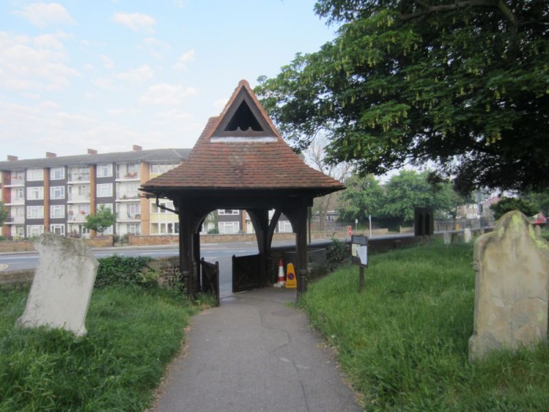
PERRY STREET
1.
5005
Crayford
Lychgate to west of
Parish Church of
St Paulinus
TQ 57 NW 3/9A
II GV
2.
Situated off of Church Hill. Probably late C19. Hexagonal lychgate; wood;
tiled roof, with tall gablets pierced by 5 graduated lancet openings.
Included for group value with church.
Listing NGR: TQ5114375108
External links are from the relevant listing authority and, where applicable, Wikidata. Wikidata IDs may be related buildings as well as this specific building. If you want to add or update a link, you will need to do so by editing the Wikidata entry.


Other nearby listed buildings