Latitude: 51.323 / 51°19'22"N
Longitude: 0.0558 / 0°3'20"E
OS Eastings: 543342
OS Northings: 160222
OS Grid: TQ433602
Mapcode National: GBR NW.DQ9
Mapcode Global: VHHPH.X0BL
Plus Code: 9F3283F4+68
Entry Name: Luxted Farmhouse
Listing Date: 29 June 1973
Grade: II
Source: Historic England
Source ID: 1064395
English Heritage Legacy ID: 358520
ID on this website: 101064395
Location: Luxted, Bromley, London, BR6
County: London
District: Bromley
Electoral Ward/Division: Darwin
Parish: Non Civil Parish
Built-Up Area: Downe
Traditional County: Kent
Lieutenancy Area (Ceremonial County): Greater London
Church of England Parish: Downe St Mary Magdalene
Church of England Diocese: Rochester
Tagged with: Farmhouse
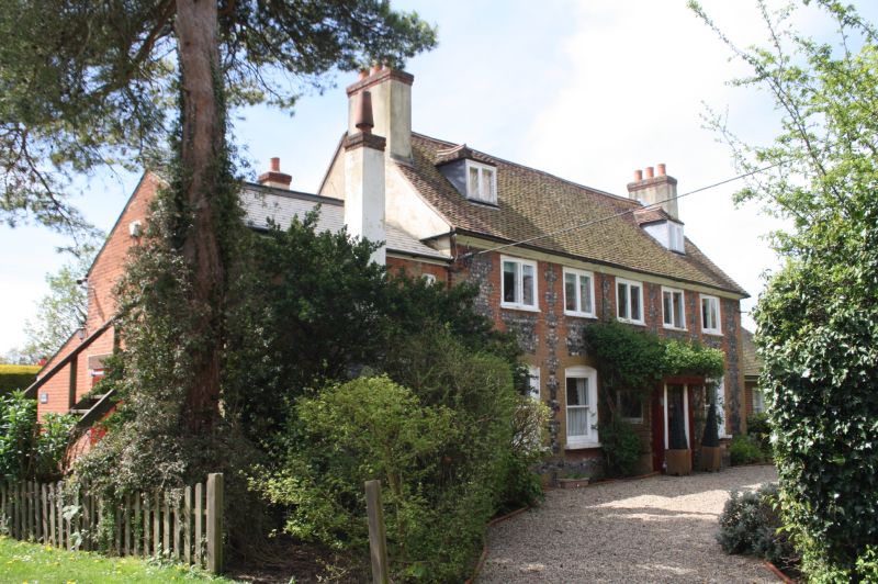
LUXTED ROAD, DOWNE
1.
4407
Luxted Farmhouse
TQ 46 SW 12/159
II
2.
C18. 2 storeys and attic. 5 windows. 2 gabled dormers. Faced with
knapped flints with vertical strips of red brick like quoins. Tiled roof.
Casement windows. Modern porch.
Listing NGR: TQ4334260222
External links are from the relevant listing authority and, where applicable, Wikidata. Wikidata IDs may be related buildings as well as this specific building. If you want to add or update a link, you will need to do so by editing the Wikidata entry.


Other nearby listed buildings