Latitude: 51.5089 / 51°30'31"N
Longitude: -0.0303 / 0°1'49"W
OS Eastings: 536789
OS Northings: 180722
OS Grid: TQ367807
Mapcode National: GBR K4.P1F
Mapcode Global: VHGR1.FBBM
Plus Code: 9C3XGX59+HV
Entry Name: St Dunstan's Wharf
Listing Date: 27 September 1973
Grade: II
Source: Historic England
Source ID: 1065131
English Heritage Legacy ID: 206126
ID on this website: 101065131
Location: Limehouse, Tower Hamlets, London, E14
County: London
District: Tower Hamlets
Electoral Ward/Division: Limehouse
Parish: Non Civil Parish
Built-Up Area: Tower Hamlets
Traditional County: Middlesex
Lieutenancy Area (Ceremonial County): Greater London
Church of England Parish: St Anne Limehouse
Church of England Diocese: London
Tagged with: Building
This list entry was subject to a Minor Amendment on 18 March 2025 to reformat the text to current standards.
TQ 3680
24/913
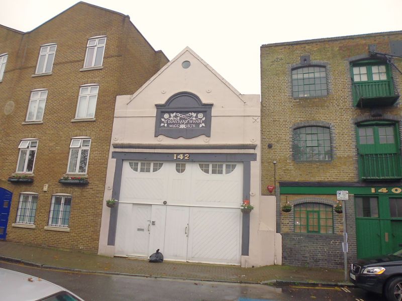
NARROW STREET E14 (south side)
No 142
GV
II
Dated 1873 on the front, or Narrow Street elevation. Rendered facade with brick coping to gable end with band below. Metal plaque records date and "St Dunstan's Wharf" and is set in raised surround. Of two storey height but most of this occupied by large double doors. Rear elevation to dock rebuilt in modern brickwork.
The warehouses on Dunbar Wharf and Nos 142, 148 and 150 form a group above Limekiln Dock.
Listing NGR: TQ3678980722
This list entry was subject to a Minor Amendment on 26 March 2026 to reformat the text to current standards.
TQ 3680
24/913
NARROW STREET E14 (south side)
No 142
GV
II
Dated 1878 on the front, or Narrow Street elevation. Rendered facade with brick coping to gable end with band below. Metal plaque records date and "St Dunstan's Wharf" and is set in raised surround. Of two storey height but most of this occupied by large double doors. Rear elevation to dock rebuilt in modern brickwork.
The warehouses on Dunbar Wharf and Nos 142, 148 and 150 form a group above Limekiln Dock.
Listing NGR: TQ3678980722
External links are from the relevant listing authority and, where applicable, Wikidata. Wikidata IDs may be related buildings as well as this specific building. If you want to add or update a link, you will need to do so by editing the Wikidata entry.


Other nearby listed buildings