Approximate Location Map
Large Map »
Latitude: 52.7986 / 52°47'55"N
Longitude: -2.0187 / 2°1'7"W
OS Eastings: 398834
OS Northings: 322340
OS Grid: SJ988223
Mapcode National: GBR 28D.DG0
Mapcode Global: WHBDV.YXWD
Plus Code: 9C4VQXXJ+CG
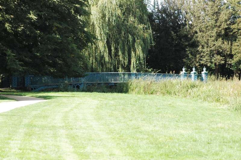
Entry Name: Footbridge at Shugborough Park
Listing Date: 10 January 1972
Grade: II
Source: Historic England
Source ID: 1065772
English Heritage Legacy ID: 443266
ID on this website: 101065772
Location: Great Haywood, Stafford, Staffordshire, ST17
County: Staffordshire
District: Stafford
Civil Parish: Tixall
Traditional County: Staffordshire
Lieutenancy Area (Ceremonial County): Staffordshire
Church of England Parish: Tixall St John the Baptist
Church of England Diocese: Lichfield
Tagged with: Footbridge
COLWICH
1.
2385
Footbridge at
8hugborough Hall
SJ 92 SE 19/36
II
2.
Probably late C18. Metal and of 3 short spans with elaborate open~work
parapets. Little used in recent times and now unsafe.
Listing NGR: SJ9883422340
External links are from the relevant listing authority and, where applicable, Wikidata. Wikidata IDs may be related buildings as well as this specific building. If you want to add or update a link, you will need to do so by editing the Wikidata entry.


Other nearby listed buildings
