Latitude: 53.5171 / 53°31'1"N
Longitude: -2.3357 / 2°20'8"W
OS Eastings: 377835
OS Northings: 402318
OS Grid: SD778023
Mapcode National: GBR DW4R.3Y
Mapcode Global: WH983.3V0M
Plus Code: 9C5VGM87+RP
Entry Name: 119, Station Road
Listing Date: 12 February 1981
Grade: II
Source: Historic England
Source ID: 1067515
English Heritage Legacy ID: 211974
ID on this website: 101067515
Location: Newtown, Salford, Greater Manchester, M27
County: Salford
Electoral Ward/Division: Swinton North
Parish: Non Civil Parish
Built-Up Area: Salford
Traditional County: Lancashire
Lieutenancy Area (Ceremonial County): Greater Manchester
Church of England Parish: Swinton and Pendlebury Team
Church of England Diocese: Manchester
Tagged with: Building
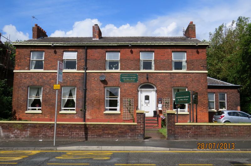
SWINTON & PENDLEBURY STATION ROAD
SD 70 SE
(west side)
2/17 No. 119
12/2/81
G.V. II
House. c.1835. Flemish bond brick with slate roof. Double-
depth plan with a total of 5 bays and 2 storeys. 4-panel
door in bay 4 with engaged Tuscan columns and plain
segmental fanlight. 4 ground and 5 first floor sash windows
(no glazing bars). First floor sill band. Wood eaves
cornice. Ridge and gable chimney stacks. Single-storey 2-
window wing of slightly later date to right gable-end and a
wing to rear.
Listing NGR: SD7783502318
External links are from the relevant listing authority and, where applicable, Wikidata. Wikidata IDs may be related buildings as well as this specific building. If you want to add or update a link, you will need to do so by editing the Wikidata entry.


Other nearby listed buildings