Approximate Location Map
Large Map »
Latitude: 53.4748 / 53°28'29"N
Longitude: -2.1497 / 2°8'58"W
OS Eastings: 390162
OS Northings: 397570
OS Grid: SJ901975
Mapcode National: GBR FXF8.D3
Mapcode Global: WHB9H.YXJK
Plus Code: 9C5VFVF2+W4
Entry Name: Sundial in Burial Ground South of Church
Listing Date: 14 July 1987
Grade: II
Source: Historic England
Source ID: 1067587
English Heritage Legacy ID: 438583
ID on this website: 101067587
Location: Droylsden, Tameside, Greater Manchester, M43
County: Tameside
Electoral Ward/Division: Droylsden East
Parish: Non Civil Parish
Built-Up Area: Droylsden
Traditional County: Lancashire
Lieutenancy Area (Ceremonial County): Greater Manchester
Church of England Parish: Droylsden St Mary
Church of England Diocese: Manchester
Tagged with: Sundial
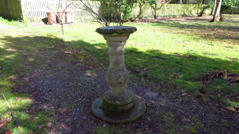
DROYLSDEN FAIRFIELD SQUARE
SJ 99 NW
4/88 Sundial in burial
ground south of
Church
G.V. II
Sundial shaft. 1/85. Baluster-type shaft with stylized leaf
enrichment. Dial and gnomon which were dated 1785 are
missing.
Listing NGR: SJ9016297570
External links are from the relevant listing authority and, where applicable, Wikidata. Wikidata IDs may be related buildings as well as this specific building. If you want to add or update a link, you will need to do so by editing the Wikidata entry.


Other nearby listed buildings
