Approximate Location Map
Large Map »
Latitude: 52.2579 / 52°15'28"N
Longitude: -1.1747 / 1°10'28"W
OS Eastings: 456428
OS Northings: 262514
OS Grid: SP564625
Mapcode National: GBR 8S1.HTC
Mapcode Global: VHCVC.LHBY
Plus Code: 9C4W7R5G+54
Entry Name: Manor House
Listing Date: 4 December 1953
Grade: II
Source: Historic England
Source ID: 1067672
English Heritage Legacy ID: 359967
ID on this website: 101067672
Location: Drayton, West Northamptonshire, NN11
County: West Northamptonshire
Civil Parish: Daventry
Built-Up Area: Daventry
Traditional County: Northamptonshire
Lieutenancy Area (Ceremonial County): Northamptonshire
Church of England Parish: Daventry Holy Cross
Church of England Diocese: Peterborough
Tagged with: House
ORCHARD STREET
1.
5324
Drayton
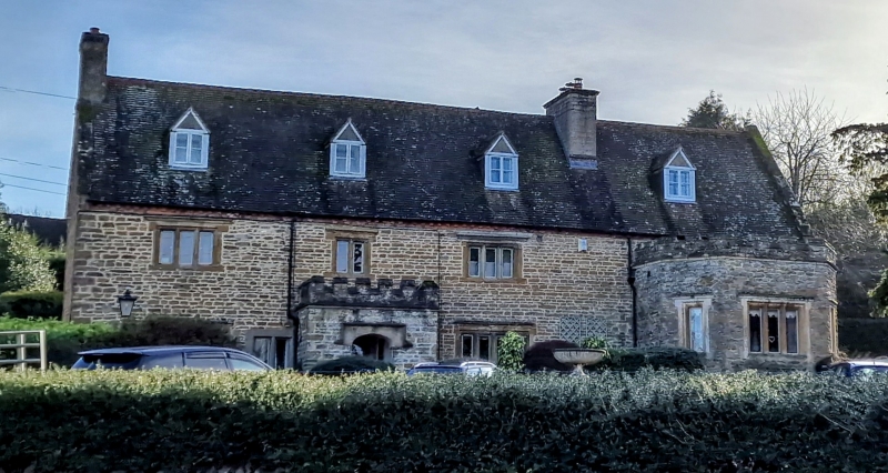
Manor House
SP 5662 1/11 4.12.53.
II GV
2.
C17 or early C18. Porch date stone 1704, porch rebuilt C19 with embattled parapet.
Stone, old and machine tiled roof with 4 gabled dormers. 2 storeys and attics,
3 triple light casement windows with stone mullions and cornices. C19 bay on right
of ground floor.
Listing NGR: SP5719462530
External links are from the relevant listing authority and, where applicable, Wikidata. Wikidata IDs may be related buildings as well as this specific building. If you want to add or update a link, you will need to do so by editing the Wikidata entry.


Other nearby listed buildings
