Approximate Location Map
Large Map »
Latitude: 52.2591 / 52°15'32"N
Longitude: -1.1735 / 1°10'24"W
OS Eastings: 456510
OS Northings: 262648
OS Grid: SP565626
Mapcode National: GBR 8S1.B43
Mapcode Global: VHCVC.LHZ0
Plus Code: 9C4W7R5G+JJ
Entry Name: The Orchards
Listing Date: 19 September 1977
Grade: II
Source: Historic England
Source ID: 1067674
English Heritage Legacy ID: 359970
ID on this website: 101067674
Location: Drayton, West Northamptonshire, NN11
County: West Northamptonshire
Civil Parish: Daventry
Built-Up Area: Daventry
Traditional County: Northamptonshire
Lieutenancy Area (Ceremonial County): Northamptonshire
Church of England Parish: Daventry Holy Cross
Church of England Diocese: Peterborough
Tagged with: Building
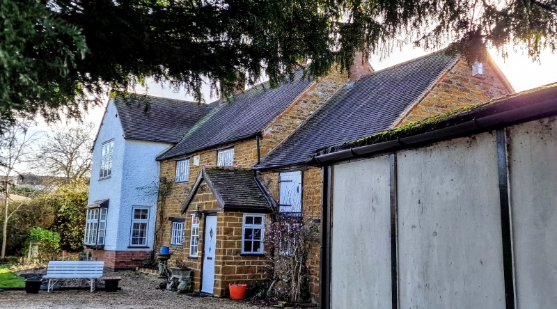
SCHOOL STREET
1.
5324
Drayton
The Orchards
SP 5662 1/118
II
2.
C17 or earlier detached house standing back from road and screened by walls and
trees. C17 block of coursed rubble with red brick cornice to oled tiled roof.
2 storeys. 2 nearly flush casement windows with glazing bars under wood. lintels.Lower
1 window wing on right with loft door to 1st floor. Modern cross wing on left
of whitewashed pebbledash.
Listing NGR: SP5651062648
External links are from the relevant listing authority and, where applicable, Wikidata. Wikidata IDs may be related buildings as well as this specific building. If you want to add or update a link, you will need to do so by editing the Wikidata entry.


Other nearby listed buildings
