Latitude: 52.1979 / 52°11'52"N
Longitude: 0.1224 / 0°7'20"E
OS Eastings: 545152
OS Northings: 257639
OS Grid: TL451576
Mapcode National: GBR L7H.1S0
Mapcode Global: VHHK9.20KY
Plus Code: 9F4254XC+5X
Entry Name: Hobson's Conduit
Listing Date: 26 April 1950
Grade: II*
Source: Historic England
Source ID: 1067788
English Heritage Legacy ID: 47826
ID on this website: 101067788
Location: Cambridge, Cambridgeshire, CB2
County: Cambridgeshire
District: Cambridge
Electoral Ward/Division: Market
Parish: Non Civil Parish
Built-Up Area: Cambridge
Traditional County: Cambridgeshire
Lieutenancy Area (Ceremonial County): Cambridgeshire
Church of England Parish: Cambridge St Benedict
Church of England Diocese: Ely
Tagged with: Fountain Architectural structure
TRUMPINGTON ROAD
1.
942
(East Side)
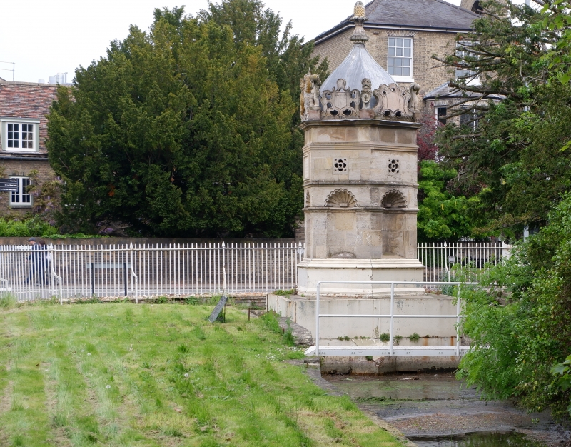
TL 4557 NW 10/209 26.4.50. Hobson's Conduit
II*
2.
Erected on Market Hill 1614, re-erected in present position in 1856. Hexagonal
stone structure with moulded plinth; niche in each side with shell-head;
entablature surmounted by strapwork cresting, achievement of Royal Arms
on one side, putti and carved beasts at angles and ogee-shaped top surmounted
by pineapple finial. Restored 1967. Interesting as the fountainhead of
a very early public water supply. See also Market Hill. (RCHM 79).
Listing NGR: TL4515257638
External links are from the relevant listing authority and, where applicable, Wikidata. Wikidata IDs may be related buildings as well as this specific building. If you want to add or update a link, you will need to do so by editing the Wikidata entry.


Other nearby listed buildings