Latitude: 53.4661 / 53°27'57"N
Longitude: -2.4901 / 2°29'24"W
OS Eastings: 367558
OS Northings: 396706
OS Grid: SJ675967
Mapcode National: GBR CX1C.P7
Mapcode Global: WH98D.Q4FN
Plus Code: 9C5VFG85+CW
Entry Name: Light Oaks Hall
Listing Date: 7 November 1966
Grade: II*
Source: Historic England
Source ID: 1068483
English Heritage Legacy ID: 213502
ID on this website: 101068483
Location: Glazebury, Wigan, Greater Manchester, WA3
County: Wigan
Electoral Ward/Division: Astley Mosley Common
Parish: Non Civil Parish
Traditional County: Lancashire
Lieutenancy Area (Ceremonial County): Greater Manchester
Church of England Parish: Glazebury All Saints
Church of England Diocese: Liverpool
Tagged with: Architectural structure
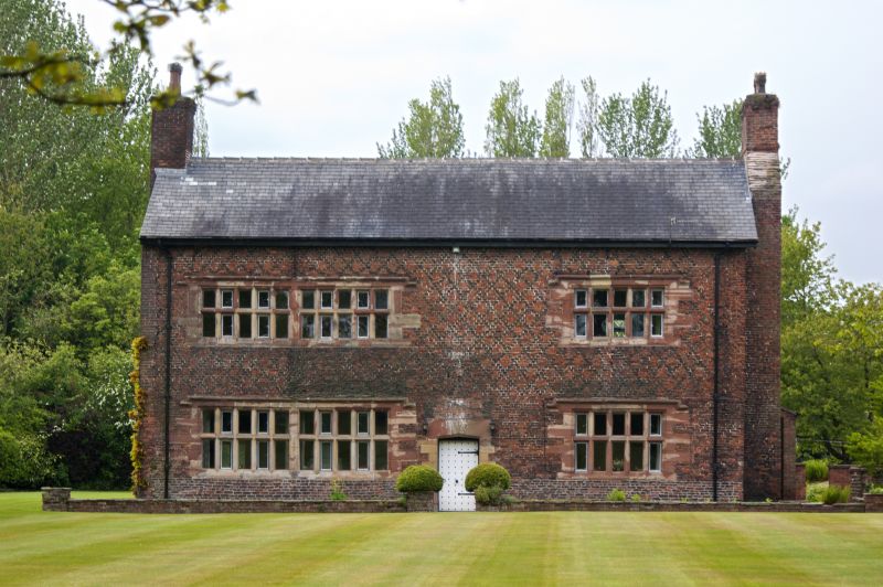
LEIGH LIGHT OAKS ROAD SD 69 NE (north side) 6/34 Light Oaks Hall 7/11/66 II* House. Early C17. Brick with stone dressings and slate roof. 2 bays and 2 storeys remain of a former 3-bay house. The left gable was rebuilt and the rear added to in C20. Bay 1 has a 10-light double-chamfered stone mullion window with king mullion on each floor. Bay 2 has a similar 5-light window on each floor. All have hoodmoulds. In between is the original studded door in a heavy chamfered surround with obtuse-angled lintel. The most notable feature of the elevation is the use of lozenge pattern decoration in black brick headers over the entire first floor. Bold projecting chimney stack to right gable-end. A small wing projects to the rear of the right bay and a C20 extension to rear of left bay. Despite the loss of a bay to the left, the elevation is of exceptional quality. Interior: the main door opens directly into the house-part which has C17 panelling throughout. The panelling includes 3 armorial panels and a fourth with combined arms and a date of 1657. 3 heavy ovolo-moulded beams with stepped stops. C20 fire surround and overmantle. Victoria County History of Lancashire, 1907.
Listing NGR: SJ6755896706
External links are from the relevant listing authority and, where applicable, Wikidata. Wikidata IDs may be related buildings as well as this specific building. If you want to add or update a link, you will need to do so by editing the Wikidata entry.


Other nearby listed buildings