Approximate Location Map
Large Map »
Latitude: 51.314 / 51°18'50"N
Longitude: 0.8912 / 0°53'28"E
OS Eastings: 601588
OS Northings: 161175
OS Grid: TR015611
Mapcode National: GBR SW3.J5C
Mapcode Global: VHKJW.D7JK
Plus Code: 9F328V7R+HF
Entry Name: 18 and 19, Preston Street
Listing Date: 3 August 1972
Grade: II
Source: Historic England
Source ID: 1069441
English Heritage Legacy ID: 175983
ID on this website: 101069441
Location: Faversham, Swale, Kent, ME13
County: Kent
District: Swale
Civil Parish: Faversham
Built-Up Area: Faversham
Traditional County: Kent
Lieutenancy Area (Ceremonial County): Kent
Tagged with: Building
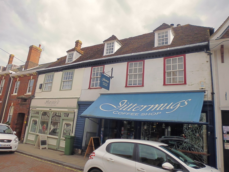
PRESTON STREET
1.
1103 (East Side)
--------------
Nos 18 & 19
TR 0161 SE 3/49
II GV
2.
1 building. C18. 2 storeys. 5 windows and 3 hipped dormers in all.
Stuccoed, Modillion eaves cornice. Glazing bars intact on 1st
floor. Modern shop fronts. Lean-to addition at the south
side.
Nos 7 to l9A (consec) form a group.
Listing NGR: TR0159261175
External links are from the relevant listing authority and, where applicable, Wikidata. Wikidata IDs may be related buildings as well as this specific building. If you want to add or update a link, you will need to do so by editing the Wikidata entry.


Other nearby listed buildings
