Latitude: 51.2448 / 51°14'41"N
Longitude: 1.3085 / 1°18'30"E
OS Eastings: 631005
OS Northings: 154720
OS Grid: TR310547
Mapcode National: GBR X1F.TY1
Mapcode Global: VHLGR.MZL2
Plus Code: 9F3368V5+W9
Entry Name: Albion Place
Listing Date: 26 November 1987
Grade: II
Source: Historic England
Source ID: 1070212
English Heritage Legacy ID: 178152
ID on this website: 101070212
Location: Eastry, Dover, Kent, CT13
County: Kent
District: Dover
Civil Parish: Eastry
Built-Up Area: Eastry
Traditional County: Kent
Lieutenancy Area (Ceremonial County): Kent
Tagged with: Building
EASTRY CHURCH STREET TR3054 & TR 3154 (west side) 12 & 13/121 Nos 1&2 Albion Place GV II
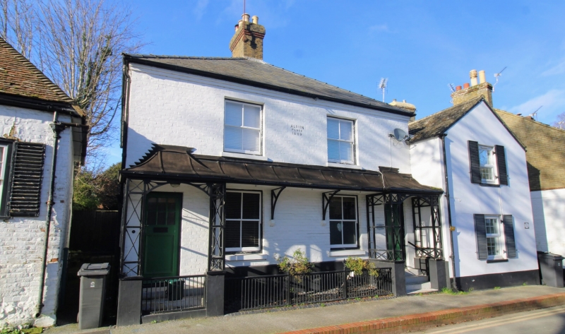
House pair. Dated 1889. Painted brick and slate roof. Two storeys on plinth with tented verandah on wooden brackets, stepped to left and right over doors. Brick eaves cornice to hipped roof with central stack. Regular fenestration of 2 sashes on each floor, those on first floor with louvred shutters. Half- glazed door to left, boarded door to right both with trellised porches at head of flights of 4 steps to right door and 3 to left door. Included for group value.
Listing NGR: TR3100054713
External links are from the relevant listing authority and, where applicable, Wikidata. Wikidata IDs may be related buildings as well as this specific building. If you want to add or update a link, you will need to do so by editing the Wikidata entry.


Other nearby listed buildings