Approximate Location Map
Large Map »
Latitude: 51.0525 / 51°3'9"N
Longitude: 0.63 / 0°37'48"E
OS Eastings: 584426
OS Northings: 131419
OS Grid: TQ844314
Mapcode National: GBR QW6.XS5
Mapcode Global: FRA D66B.P7Q
Plus Code: 9F323J3J+22
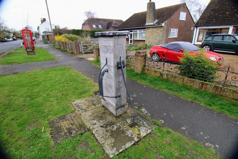
Entry Name: Village Pump Opposite No 29
Listing Date: 9 August 1979
Grade: II
Source: Historic England
Source ID: 1070926
English Heritage Legacy ID: 180353
ID on this website: 101070926
Location: Rolvenden, Ashford, Kent, TN17
County: Kent
District: Ashford
Civil Parish: Rolvenden
Built-Up Area: Rolvenden
Traditional County: Kent
Lieutenancy Area (Ceremonial County): Kent
Tagged with: Well
ROLVENDEN HIGH STEEET
1.
5272 (east side)
Village Pump
opposite No 29
TQ 8431 18/309
II
2.
C19 pump with leaf spout and iron handle enclosed within oblong wooden case.
Listing NGR: TQ8442631419
External links are from the relevant listing authority and, where applicable, Wikidata. Wikidata IDs may be related buildings as well as this specific building. If you want to add or update a link, you will need to do so by editing the Wikidata entry.


Other nearby listed buildings
