Approximate Location Map
Large Map »
Latitude: 51.1945 / 51°11'40"N
Longitude: 0.7281 / 0°43'41"E
OS Eastings: 590715
OS Northings: 147460
OS Grid: TQ907474
Mapcode National: GBR QTS.4WN
Mapcode Global: VHKKC.K7SM
Plus Code: 9F325PVH+R6
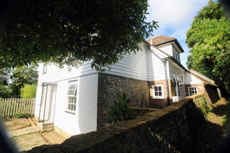
Entry Name: The Cottage
Listing Date: 10 October 1980
Grade: II
Source: Historic England
Source ID: 1071494
English Heritage Legacy ID: 180878
ID on this website: 101071494
Location: Egerton, Ashford, Kent, TN27
County: Kent
District: Ashford
Civil Parish: Egerton
Traditional County: Kent
Lieutenancy Area (Ceremonial County): Kent
Tagged with: Cottage
1.
5272 EGERTON THE STREET
(north-west side)
The Cottage
TQ 94 NW 10/164
II
2.
C18. Two storeys. Ground floor painted brick, above weatherboarded. Hipped
tiled roof. Two sashes with glazing bars intact. Trellis work porch. Later
extension to rear.
Listing NGR: TQ9071047466
External links are from the relevant listing authority and, where applicable, Wikidata. Wikidata IDs may be related buildings as well as this specific building. If you want to add or update a link, you will need to do so by editing the Wikidata entry.


Other nearby listed buildings
