Latitude: 53.7311 / 53°43'51"N
Longitude: -2.3948 / 2°23'41"W
OS Eastings: 374052
OS Northings: 426151
OS Grid: SD740261
Mapcode National: GBR CTQ9.B7
Mapcode Global: WH973.5HW0
Plus Code: 9C5VPJJ4+C3
Entry Name: Jackhouse Farmhouse
Listing Date: 15 November 1965
Last Amended: 9 March 1984
Grade: II
Source: Historic England
Source ID: 1072739
English Heritage Legacy ID: 183888
ID on this website: 101072739
Location: Hoyle Bottom, Hyndburn, Lancashire, BB5
County: Lancashire
District: Hyndburn
Electoral Ward/Division: Immanuel
Parish: Non Civil Parish
Traditional County: Lancashire
Lieutenancy Area (Ceremonial County): Lancashire
Church of England Parish: Oswaldtwistle
Church of England Diocese: Blackburn
Tagged with: Farmhouse
OSWALDTWISTLE COBB LANE SD 72 NW 4/85 Jackhouse Farmhouse 15.11.1965 (Formerly listed as Jackhouse) - II
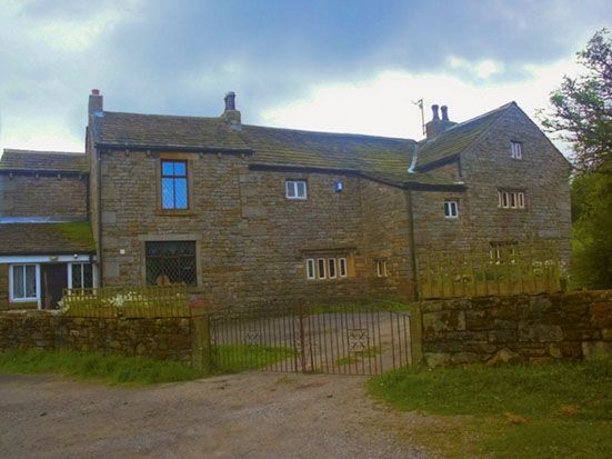
Farmhouse, Cl7, with C19 addition at east end, west wing in course of restoration (1983); now house. Coursed sandstone with large quoins, stone slate roof. T-plan: one bay (extended to 2) with 2-bay crosswing. Two storeys; original front south has at ground floor a 6-light double chamfered stone mullion window with hoodmould, at 1st floor 2 mullioned windows of unequal size (close together); gable of wing has similar 5-light windows with hoodmoulds, the lower window damaged. Rear has another similar window of 4 lights with hoodmould, stair turret in angle of wing, and 3 windows (one on each floor) with 4 lights at 1st floor, 2 lights in attic. (Ainsworth Homesteads pp.244-8).
Listing NGR: SD7405226151
External links are from the relevant listing authority and, where applicable, Wikidata. Wikidata IDs may be related buildings as well as this specific building. If you want to add or update a link, you will need to do so by editing the Wikidata entry.


Other nearby listed buildings