Approximate Location Map
Large Map »
Latitude: 52.6312 / 52°37'52"N
Longitude: -1.1405 / 1°8'25"W
OS Eastings: 458272
OS Northings: 304059
OS Grid: SK582040
Mapcode National: GBR FFL.6P
Mapcode Global: WHDJJ.G446
Plus Code: 9C4WJVJ5+FR
Entry Name: Trinity House, Formerly Trinity Hospital Almshouses
Listing Date: 5 January 1950
Grade: II
Source: Historic England
Source ID: 1074792
English Heritage Legacy ID: 188751
ID on this website: 101074792
Location: Leicester, Leicestershire, LE2
County: City of Leicester
Electoral Ward/Division: Castle
Parish: Non Civil Parish
Built-Up Area: Leicester
Traditional County: Leicestershire
Lieutenancy Area (Ceremonial County): Leicestershire
Church of England Parish: Leicester St Mary de Castro
Church of England Diocese: Leicester
Tagged with: Almshouse
5304
SK 5804 SW 2/114
THE NEWARKE (North Side),
Trinity House, formerly Trinity Hospital Almshouses
(Formerly listed as Trinity Hospital Almshouses)
5.1.50
II
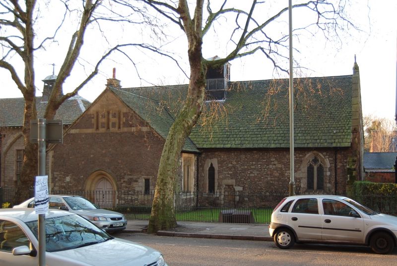
Founded in 1331 by Henry Earl of Lancaster. Rebuilt in 1901 by Goodacre and Sons, and now owned by De Montfort University. Part of the original building remains in the chapel late C14, double-chamfered chancel arch, four lancets in chancel, the entrance hall retains one and a half bays of arcade of depressed two-centred arches on octagonal piers (originally a seventeen bay hall). Monument in alabaster in poor condition, thought likely to be Lady Mary Hervey, governess to Henry V and benefactress of Trinity Hospital. C14 heraldic tiles, 1901 rebuilding consists of:- Stone rubble, slate roofs, front with pointed-arch arcading containing tall stone mullion/ transom windows with leaded panes, two of arches are open with slight projection between with sundial in gable and doorway with paired pilasters and segmental open pediment, four-centred arch door with carved spandrels. Bell-cote on roof. To right the chapel, stone rubble with steep-pitched gable-end slate roof with wood bell-cote. To left at angle following curve of road long brick range of almshouses, stone-mullion windows, gables at ends and two-storey splayed bays.
Listing NGR: SK5827204059
External links are from the relevant listing authority and, where applicable, Wikidata. Wikidata IDs may be related buildings as well as this specific building. If you want to add or update a link, you will need to do so by editing the Wikidata entry.


Other nearby listed buildings
