Latitude: 53.5518 / 53°33'6"N
Longitude: -3.0874 / 3°5'14"W
OS Eastings: 328054
OS Northings: 406678
OS Grid: SD280066
Mapcode National: GBR 6WWC.DH
Mapcode Global: WH758.KZ1J
Plus Code: 9C5RHW27+P2
Entry Name: Old Village Stocks Approximately 30 Metres South of Porch of St Lukes Church
Listing Date: 19 July 1966
Grade: II
Source: Historic England
Source ID: 1075861
English Heritage Legacy ID: 216443
ID on this website: 101075861
Location: St Luke's Church, Sefton, Merseyside, L37
County: Sefton
Civil Parish: Formby
Built-Up Area: Formby
Traditional County: Lancashire
Lieutenancy Area (Ceremonial County): Merseyside
Church of England Parish: Formby St Luke
Church of England Diocese: Liverpool
Tagged with: Building
FORMBY ST. LUKE'S CHURCH ROAD
SD 20 NE
(west side)
2/45 Old Village
Stocks approx.
30 m. south of
porch of
19.07.66 St. Luke's Church
G.V. II
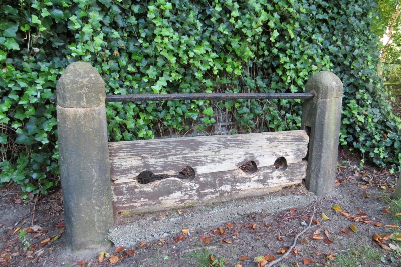
Stocks. C18. Stone piers with chamfered angles and slots
for wooden boards with iron bar above. Moved from original
site near Cross Green.
Listing NGR: SD2805406678
External links are from the relevant listing authority and, where applicable, Wikidata. Wikidata IDs may be related buildings as well as this specific building. If you want to add or update a link, you will need to do so by editing the Wikidata entry.


Other nearby listed buildings