Latitude: 51.7946 / 51°47'40"N
Longitude: -0.6557 / 0°39'20"W
OS Eastings: 492804
OS Northings: 211514
OS Grid: SP928115
Mapcode National: GBR F4N.H1F
Mapcode Global: VHFRW.L563
Plus Code: 9C3XQ8VV+RP
Entry Name: Milepost Near the Garden House
Listing Date: 29 May 1986
Grade: II
Source: Historic England
Source ID: 1078037
English Heritage Legacy ID: 355721
ID on this website: 101078037
Location: Tring, Dacorum, Hertfordshire, HP23
County: Hertfordshire
District: Dacorum
Civil Parish: Tring
Built-Up Area: Tring
Traditional County: Hertfordshire
Lieutenancy Area (Ceremonial County): Hertfordshire
Church of England Parish: Tring
Church of England Diocese: St.Albans
Tagged with: Milestone
TRING LONDON ROAD (A41)
SP 9211
(South side)
11/85 Milepost near
- The Garden House
- II
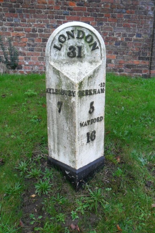
Milepost. '1826' inscribed on back. For Sparrows Herne Turnpike Trust.
Cast iron, painted. An iron milepost, hollow at the back with prismatic
front, and semi-circular head with raised edge bead. In raised lettering
in an arc on the head 'LONDON/31'. on E face 'AYLESBURY/7'. On W face
'BERKHAM-SD/5/WATFORD/16'. Inscribed in the back at the head 'LONDON/RI
& I BARNETT/FOUNDERS 1826'. (Branch Johnson(1970)186).
Listing NGR: SP9280511513
External links are from the relevant listing authority and, where applicable, Wikidata. Wikidata IDs may be related buildings as well as this specific building. If you want to add or update a link, you will need to do so by editing the Wikidata entry.


Other nearby listed buildings