Approximate Location Map
Large Map »
Latitude: 51.76 / 51°45'35"N
Longitude: -0.5622 / 0°33'43"W
OS Eastings: 499331
OS Northings: 207785
OS Grid: SP993077
Mapcode National: GBR F55.NP0
Mapcode Global: VHFS4.61N4
Plus Code: 9C3XQC5Q+X4
Entry Name: The Court House
Listing Date: 9 May 1973
Grade: II
Source: Historic England
Source ID: 1078131
English Heritage Legacy ID: 355437
ID on this website: 101078131
Location: Berkhamsted, Dacorum, Hertfordshire, HP4
County: Hertfordshire
District: Dacorum
Civil Parish: Berkhamsted
Built-Up Area: Berkhamsted
Traditional County: Hertfordshire
Lieutenancy Area (Ceremonial County): Hertfordshire
Church of England Parish: Great Berkhamsted
Church of England Diocese: St.Albans
Tagged with: House
1.
839
CHURCH LANE
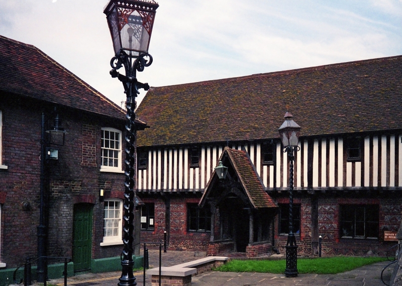
The Court House
SP 9907 NW 1/9
II
2.
C16, much restored C19 ground floor of red brickwork and knapped flints;
1st floor jettied timber framework. Old tiled roof. Cl9 casement windows.
The Borough Court or Port Mote was held here. Subsequently used as a national
school.
Listing NGR: SP9933107785
External links are from the relevant listing authority and, where applicable, Wikidata. Wikidata IDs may be related buildings as well as this specific building. If you want to add or update a link, you will need to do so by editing the Wikidata entry.


Other nearby listed buildings
