Approximate Location Map
Large Map »
Latitude: 51.7621 / 51°45'43"N
Longitude: -0.5701 / 0°34'12"W
OS Eastings: 498777
OS Northings: 208016
OS Grid: SP987080
Mapcode National: GBR F55.DPC
Mapcode Global: VHFRY.2ZG1
Plus Code: 9C3XQC6H+VW
Entry Name: The Lamb Public House
Listing Date: 9 May 1973
Grade: II
Source: Historic England
Source ID: 1078146
English Heritage Legacy ID: 355473
Also known as: The Lamb, Berkhamsted
Lamb
ID on this website: 101078146
Location: Berkhamsted, Dacorum, Hertfordshire, HP4
County: Hertfordshire
District: Dacorum
Civil Parish: Berkhamsted
Built-Up Area: Berkhamsted
Traditional County: Hertfordshire
Lieutenancy Area (Ceremonial County): Hertfordshire
Church of England Parish: Great Berkhamsted
Church of England Diocese: St.Albans
Tagged with: Pub
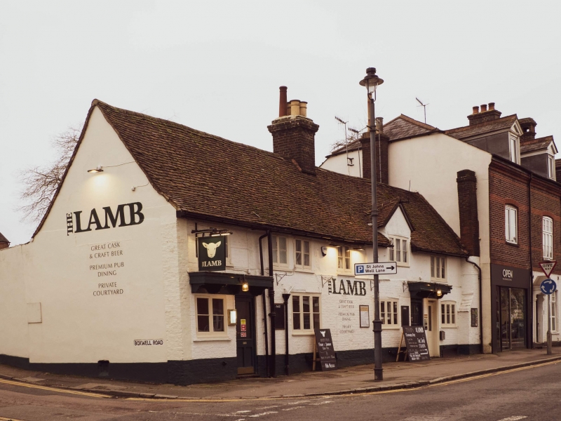
1.
839 HIGH STREET
(South Side)
No 277
(The Lamb Public House)
SP 9808 SE 4/140
II
2.
C17 altered; Painted brick, old tiled roof. 2 storeys, 6 casements including
1st floor gabled half dormer, Carriageway on left. Pair of doors on right
under cut bracketed doorhood.
Listing NGR: SP9877708016
External links are from the relevant listing authority and, where applicable, Wikidata. Wikidata IDs may be related buildings as well as this specific building. If you want to add or update a link, you will need to do so by editing the Wikidata entry.


Other nearby listed buildings
