Approximate Location Map
Large Map »
Latitude: 51.5155 / 51°30'55"N
Longitude: -0.1264 / 0°7'35"W
OS Eastings: 530102
OS Northings: 181284
OS Grid: TQ301812
Mapcode National: GBR HB.SX
Mapcode Global: VHGQZ.R5JK
Plus Code: 9C3XGV8F+6C
Entry Name: St Mungo's Housing
Listing Date: 15 January 1973
Last Amended: 11 January 1999
Grade: II
Source: Historic England
Source ID: 1078296
English Heritage Legacy ID: 477189
ID on this website: 101078296
Location: St Giles, Camden, London, WC2H
County: London
District: Camden
Electoral Ward/Division: Holborn and Covent Garden
Parish: Non Civil Parish
Built-Up Area: Camden
Traditional County: Middlesex
Lieutenancy Area (Ceremonial County): Greater London
Church of England Parish: St Giles-in-the-Fields
Church of England Diocese: London
Tagged with: Homeless shelter
TQ3081SW
798-1/105/388
CAMDEN
ENDELL STREET (South West side)
No.83 St Mungo's Housing
(Formerly Listed as: ST GILES HIGH STREET St Giles in the Fields Church of England Primary School)
15/01/73
GV
II
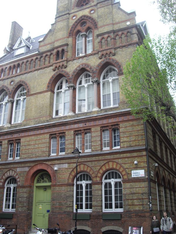
School now a hostel for the homeless. 1860. By E.M Barry. Polychrome brick with some terracotta and stone dressings under a slate roof in tough Gothic revival style. Rectangular plan on the corner of Endell Street and High Holborn.
EXTERIOR: entrance front on Endell Street, Four storeys, basement and dormers, five windows (seven windows on return to High Holborn). Ground floor yellow stock brick with red brick bands with paired, pointed-arch windows and centrally placed doorway with fanlight and stone either side of round arch inscribed NATIONAL SCHOOLS. String course at first floor level on which recessed square headed windows with brick mullions under a continuous band of decorative blue and red tiles. Second floor to left, a pair of pointed arch, decorative terracotta tiled windows with a marble colonnette. To the right, three identical pointed arch windows under an asymmetrically placed gable containing two lancet windows with marble colonnette and oculus above under a pointed terracotta arch. Trefoil window in pointed arch in the apex. To either side, rising through the gable, vertical brick features. The third floor comprises a continuous mostly blind arcade of pointed arches to eaves level. High Holborn return has similar fenestration and dressings with two large dormers and scattered small ones.
INTERIOR: altered but retains some original features.
HISTORICAL NOTE: built as parish schools for 1500 children, together with an industrial school and soup kitchen for the poor of the Drury Lane slums.
Listing NGR: TQ3010281284
External links are from the relevant listing authority and, where applicable, Wikidata. Wikidata IDs may be related buildings as well as this specific building. If you want to add or update a link, you will need to do so by editing the Wikidata entry.


Other nearby listed buildings
