Latitude: 51.5396 / 51°32'22"N
Longitude: -0.0681 / 0°4'5"W
OS Eastings: 534073
OS Northings: 184065
OS Grid: TQ340840
Mapcode National: GBR X2.T8
Mapcode Global: VHGQT.RKVM
Plus Code: 9C3XGWQJ+RP
Entry Name: 15-21, ALBION DRIVE E8 (See details for further address information)
Listing Date: 4 February 1975
Grade: II
Source: Historic England
Source ID: 1079856
English Heritage Legacy ID: 201700
ID on this website: 101079856
Location: Kingsland, Hackney, London, E8
County: London
District: Hackney
Electoral Ward/Division: London Fields
Parish: Non Civil Parish
Built-Up Area: Hackney
Traditional County: Middlesex
Lieutenancy Area (Ceremonial County): Greater London
Church of England Parish: St Michael and All Angels London Fields
Church of England Diocese: London
Tagged with: Building
1. ALBION DRIVE E8 5013 (North Side) --------------- Nos 15 to 21 (odd) Nos 25 & 27 TQ 3484 25/4 II GV
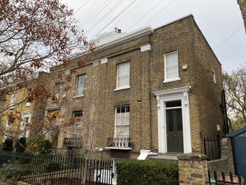
2. 3 mid C19 pairs, each 2 storeys andbasement, 1 window in main block, one in slightly set back outer entrance bay. Stock brick. Stucco cornice, blocking course and raised central parapet to main block, inscribed: ALBION VILLAS. Stuccoed parapet coping to side bays. Below this a brick architrave rests on 4 giant pilasters with stuccoed capitals and bases, resting on low basement plinth. Gauged flat brick arches to sash windows with glazing bars, those on ground floor having ornamental cast iron balconies. 6 steps to 4-panel doors (some now modernised), with rectangular fanlights, in moulded architrave with console bracketed cornice.
Nos 15 to 21 (odd) and Nos 75 and 27 form a group.
Listing NGR: TQ3407384065
External links are from the relevant listing authority and, where applicable, Wikidata. Wikidata IDs may be related buildings as well as this specific building. If you want to add or update a link, you will need to do so by editing the Wikidata entry.


Other nearby listed buildings