Approximate Location Map
Large Map »
Latitude: 52.2718 / 52°16'18"N
Longitude: -2.0845 / 2°5'4"W
OS Eastings: 394330
OS Northings: 263739
OS Grid: SO943637
Mapcode National: GBR 2GP.FV3
Mapcode Global: VH92H.T5C9
Plus Code: 9C4V7WC8+P6
Entry Name: Retaining Wall and Adjoining Servants' Tunnel About 65 Yards North-West of Hanbury Hall
Listing Date: 4 September 1986
Grade: II
Source: Historic England
Source ID: 1081237
English Heritage Legacy ID: 147810
ID on this website: 101081237
Location: Wychavon, Worcestershire, WR9
County: Worcestershire
District: Wychavon
Civil Parish: Hanbury
Traditional County: Worcestershire
Lieutenancy Area (Ceremonial County): Worcestershire
Church of England Parish: Hanbury
Church of England Diocese: Worcester
Tagged with: Retaining wall
HANBURY CP SCHOOL ROAD (north side)
SO 96 SW
3/134 Retaining wall and
adjoining servants' tunnel
about 65 yards north-west
of Hanbury Hall
GV II
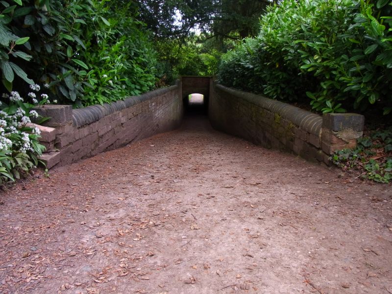
Retaining wall and adjoining servants' tunnel. Wall of early C18 origins,
remodelled in mid-C19 when tunnel added. Brick in English garden wall bond
and including some handmade bricks with sandstone copings. Roughly a quad-
rant about 25 yards long with return at east end and adjoining tunnel entrance
at north end. The tunnel is built of partly blue brick, is vaulted and runs
about 20 yards west; the walls to the west end entrance are splayed and
terminate in short square piers. The retaining wall was originally linked to
one of a pair of pavilions forming a boundary between the formal garden lay-
out by George London and the pond and deer park beyond; the original layout
is clearly illustrated in a perspective drawing of 1732 by Joseph Dougharty.
(Hanbury Hall, the National Trust Official Guidebook, 1981, p 27-30; VCH 3 (ii),
p 372-3; Country Life xxxix, 502, CXLiii, 18, 16, gardens x 368).
Listing NGR: SO9433063739
External links are from the relevant listing authority and, where applicable, Wikidata. Wikidata IDs may be related buildings as well as this specific building. If you want to add or update a link, you will need to do so by editing the Wikidata entry.


Other nearby listed buildings
