Approximate Location Map
Large Map »
Latitude: 52.2185 / 52°13'6"N
Longitude: -2.8917 / 2°53'30"W
OS Eastings: 339178
OS Northings: 258179
OS Grid: SO391581
Mapcode National: GBR FB.2CBW
Mapcode Global: VH77B.THMP
Plus Code: 9C4V6495+98
Entry Name: Range of Three Tenements to West of the Old Forge
Listing Date: 19 August 1953
Last Amended: 16 June 1987
Grade: II
Source: Historic England
Source ID: 1081727
English Heritage Legacy ID: 150320
ID on this website: 101081727
Location: Pembridge, County of Herefordshire, HR6
County: County of Herefordshire
Civil Parish: Pembridge
Built-Up Area: Pembridge
Traditional County: Herefordshire
Lieutenancy Area (Ceremonial County): Herefordshire
Church of England Parish: Pembridge with Moorcourt
Church of England Diocese: Hereford
Tagged with: Building
PEMBRIDGE CP EAST STREET (south side)
SO 3858 - 3958
10/62 Range of three tenements
to west of The Old Forge
(formerly listed as Mary
19.8.53 Radnor's Tobacco Shop next
west of item 12/18).
GV II
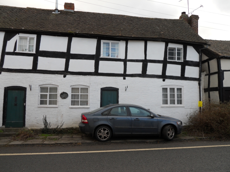
Range of three tenements (now unoccupied). C17 with late C19 alterations.
Timber-framed with ground floor refaced with brick and eastern tenement
added in brick at a later date. Wattle-and-daub infill to square panelled
timber-framing of upper floor; Welsh slate roof. Two framed bays aligned
east/west with brick addition to east end, entrances to north front end and
axial stacks. Two storeys; four 2-light casement windows on first floor, one
2-light casement window to left of door, further doorway with two casement
windows to right. Ledged door and blocked doorway and a 3-light casement
window to right. The beam supporting the upper floor appears to be moulded
and may imply that this was a jettied upper floor. (RCHM, Vol III, p 165,
item 21).
Listing NGR: SO3917458177
External links are from the relevant listing authority and, where applicable, Wikidata. Wikidata IDs may be related buildings as well as this specific building. If you want to add or update a link, you will need to do so by editing the Wikidata entry.


Other nearby listed buildings
