Approximate Location Map
Large Map »
Latitude: 52.139 / 52°8'20"N
Longitude: -3.0074 / 3°0'26"W
OS Eastings: 331152
OS Northings: 249441
OS Grid: SO311494
Mapcode National: GBR F6.7DMR
Mapcode Global: VH77N.THHM
Plus Code: 9C4R4XQV+H2
Entry Name: Oakwood
Listing Date: 19 August 1953
Grade: II
Source: Historic England
Source ID: 1082490
English Heritage Legacy ID: 150618
ID on this website: 101082490
Location: Eardisley, County of Herefordshire, HR3
County: County of Herefordshire
Civil Parish: Eardisley
Built-Up Area: Eardisley
Traditional County: Herefordshire
Lieutenancy Area (Ceremonial County): Herefordshire
Church of England Parish: Eardisley with Bollingham and Willersley
Church of England Diocese: Hereford
Tagged with: Building
SO 3049-3149
7/63
19.8.53
EARDISLEY CP
CHURCH ROAD (west side)
Oakwood
GV
II
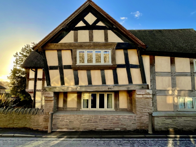
House. Late C16 with mid-C19 and mid-C20 alterations. Timber-framed with
painted brick and rendered infill on rubble base, some rubble and painted
brick replacement walling, concrete-tiled roof and brick ridge stacks. L-plan;
main range of one framed bay, aligned north/south with large chimney. Cross-
wing of three framed bays situated at south end. Two storeys. Framing: four
rows of panels from sill to wall-plate with some solid upper corner braces.
First floor and gable of cross-wing is jettied at the east end. First floor
is partly underbuilt it rubble, has a moulded bressummer and a central shaped
bracket. East front elevation: main part has a ground floor 3-light casement
with a plank weathering and a first floor 2-light casement. Cross-wing gable
end has a ground floor 2-light leaded casement, an original 3-light mullioned
first floor window, and the main entrance which has a C20 door. A first floor
window on the south side has an original moulded sill. There is also a C20
wing of two storeys at the centre of the south elevation. (RCHM, III, p 54,
item 17).
Listing NGR: SO3115249441
External links are from the relevant listing authority and, where applicable, Wikidata. Wikidata IDs may be related buildings as well as this specific building. If you want to add or update a link, you will need to do so by editing the Wikidata entry.


Other nearby listed buildings
