Latitude: 52.3082 / 52°18'29"N
Longitude: -2.2925 / 2°17'33"W
OS Eastings: 380152
OS Northings: 267829
OS Grid: SO801678
Mapcode National: GBR 0CC.96Z
Mapcode Global: VH926.67WV
Plus Code: 9C4V8P54+7X
Entry Name: Bullhill Farmhouse
Listing Date: 12 November 1951
Grade: II
Source: Historic England
Source ID: 1082710
English Heritage Legacy ID: 152256
ID on this website: 101082710
Location: Astley Burf, Malvern Hills, Worcestershire, DY13
County: Worcestershire
District: Malvern Hills
Civil Parish: Astley and Dunley
Traditional County: Worcestershire
Lieutenancy Area (Ceremonial County): Worcestershire
Church of England Parish: Astley
Church of England Diocese: Worcester
Tagged with: Farmhouse
SO 86 NW,
4/28
ASTLEY CP,
Bullhill Farmhouse
12.11.51
II
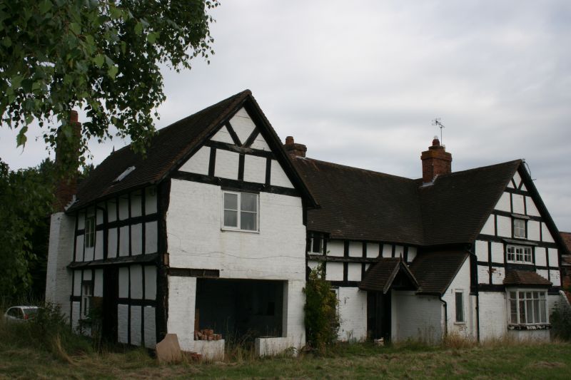
Farmhouse. Early C17. Timber-framed, ground floor partially bricked; painted
brick and lath and plaster infill panels; tiled roofs. Traditional hall and
cross wing type with central hearth and cross passage, chimney backing on
through passage; three-bay upper wing now containing kitchen, two-bay centre range
and one-bay lower wing. North front: two storeys with attic in gables, cellar
under right hand service wing, three gables; projecting cross wing to left and
pair of gables to right, over entrance and to service end. Irregular fenestration,
C20 metal casements, four on first floor, two on ground floor and two small attic windows
retaining leading. Entrance in middle gable, C20 porch, plank door and side light.
Four chimneys: one roughly central to hall-range, one roughly central to right cross-
wing which also has large external stack at gable end, fourth chimney on return
of right wing. Framing: regular square panels, formerly four from sill to eaves,
now mostly from mid-rail to eaves, V-struts in gables, curved to upper cross-
wing; weather planks at sill levels and in part to lintel levels.
Listing NGR: SO8015267829
External links are from the relevant listing authority and, where applicable, Wikidata. Wikidata IDs may be related buildings as well as this specific building. If you want to add or update a link, you will need to do so by editing the Wikidata entry.


Other nearby listed buildings