Approximate Location Map
Large Map »
Latitude: 54.0933 / 54°5'35"N
Longitude: -0.2073 / 0°12'26"W
OS Eastings: 517340
OS Northings: 467860
OS Grid: TA173678
Mapcode National: GBR VPZ3.XF
Mapcode Global: WHHF6.SCGW
Plus Code: 9C6X3QVV+83
Entry Name: 52, High Street
Listing Date: 9 January 1976
Grade: II
Source: Historic England
Source ID: 1083674
English Heritage Legacy ID: 166135
ID on this website: 101083674
Location: Old Town, East Riding of Yorkshire, YO16
County: East Riding of Yorkshire
Civil Parish: Bridlington
Built-Up Area: Bridlington
Traditional County: Yorkshire
Lieutenancy Area (Ceremonial County): East Riding of Yorkshire
Church of England Parish: Bridlington Priory Church (St Mary)
Church of England Diocese: York
Tagged with: Building
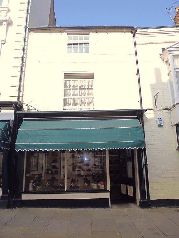
1.
5268 HIGH STREET
(North Side)
No 52
TA 1767 NW 1/163
II GV
2.
C18 origins. 3 storeys in painted brick with Welsh slate roof. Right hand build
has later front elevation, with a large late C19 rectangular bay over a window of
3 lights with segmental head. Left hand build has 1 hung sash window with glazing
bars to 2 storeys, above C19 shop front.
Nos 16 to 46 (even), 46A, 48 to 64 (even), 64A, 66 to 100 (even) form a group.
Listing NGR: TA1733367872
External links are from the relevant listing authority and, where applicable, Wikidata. Wikidata IDs may be related buildings as well as this specific building. If you want to add or update a link, you will need to do so by editing the Wikidata entry.


Other nearby listed buildings
