Latitude: 53.2477 / 53°14'51"N
Longitude: -1.6235 / 1°37'24"W
OS Eastings: 425221
OS Northings: 372365
OS Grid: SK252723
Mapcode National: GBR KZ3W.BH
Mapcode Global: WHCD2.1M6L
Plus Code: 9C5W69XG+3J
Entry Name: Churchyard Cross Circa 40 Metres North of St Annes Church
Listing Date: 19 June 1987
Grade: II
Source: Historic England
Source ID: 1084380
English Heritage Legacy ID: 81586
ID on this website: 101084380
Location: Baslow, Derbyshire Dales, Derbyshire, DE45
County: Derbyshire
District: Derbyshire Dales
Civil Parish: Baslow and Bubnell
Built-Up Area: Baslow
Traditional County: Derbyshire
Lieutenancy Area (Ceremonial County): Derbyshire
Church of England Parish: Baslow St Anne
Church of England Diocese: Derby
Tagged with: Churchyard cross
PARISH OF BASLOW & BUBNELL CHURCH LANE
SK 27 SE
3/21 (South Side)
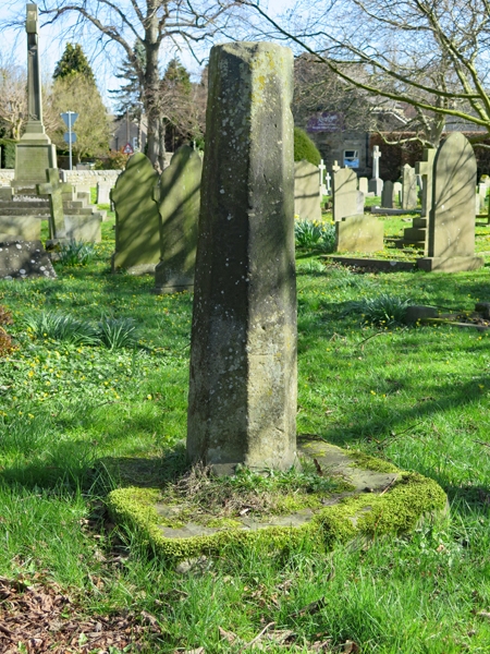
Churchyard Cross c40m
North of St Anne's
Church
GV II
Base and part of the shaft of a medieval cross. Probably C15.
Gritstone. Square base. Shaft about one metre in height,
octagonal with alternate faces stopped at the base.
Listing NGR: SK2522172365
External links are from the relevant listing authority and, where applicable, Wikidata. Wikidata IDs may be related buildings as well as this specific building. If you want to add or update a link, you will need to do so by editing the Wikidata entry.


Other nearby listed buildings