Approximate Location Map
Large Map »
Latitude: 51.3617 / 51°21'42"N
Longitude: 1.0246 / 1°1'28"E
OS Eastings: 610662
OS Northings: 166861
OS Grid: TR106668
Mapcode National: GBR TX1.FWB
Mapcode Global: VHKJR.Q11F
Plus Code: 9F33926F+MR
Entry Name: 15, Sea Street
Listing Date: 20 May 1977
Last Amended: 23 December 1977
Grade: II
Source: Historic England
Source ID: 1084913
English Heritage Legacy ID: 170867
ID on this website: 101084913
Location: Whitstable, Canterbury, Kent, CT5
County: Kent
District: Canterbury
Electoral Ward/Division: Gorrell
Parish: Non Civil Parish
Built-Up Area: Whitstable
Traditional County: Kent
Lieutenancy Area (Ceremonial County): Kent
Tagged with: Building
SEA STREET
In the entry for: 1/182
(West Street)
Nos 14 and 15
Nos 14 and 15 shall be amended to read
No 15
------------------------------------
SEA STREET
1.
5273
(West Side)
Nos 14 and 15
TR 1066 NE 1/182
II
2.
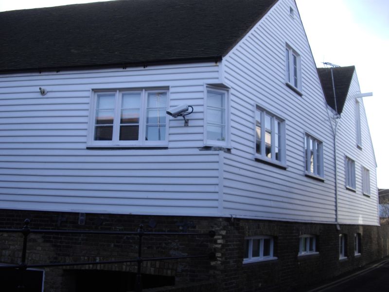
This forms 2 parallel warehouses of considerable size with a valley gutter between
them and gables onto Sea Street and Sea Wall. Late C18 to early C19. Brindle
brick ground floor, and 1st and 2nd floors timber framed with weatherboarding externally
moulded at bottom edge. Old clay tiled roof each range and groups of 3 windows
in 3 lights with laybars. The building to the west has a hoist and door under
on 2nd floor and a door upon the 1st floor. No 14 is similar but a window takes
the place of the 2nd floor door and 1st floor door boarded up.
Listing NGR: TR1066266861
External links are from the relevant listing authority and, where applicable, Wikidata. Wikidata IDs may be related buildings as well as this specific building. If you want to add or update a link, you will need to do so by editing the Wikidata entry.


Other nearby listed buildings
