Approximate Location Map
Large Map »
Latitude: 51.3612 / 51°21'40"N
Longitude: 1.0251 / 1°1'30"E
OS Eastings: 610697
OS Northings: 166804
OS Grid: TR106668
Mapcode National: GBR TX1.MYQ
Mapcode Global: VHKJR.Q18T
Plus Code: 9F33926G+F2
Entry Name: 50 and 51, Harbour Street
Listing Date: 23 December 1975
Grade: II
Source: Historic England
Source ID: 1084938
English Heritage Legacy ID: 170830
ID on this website: 101084938
Location: Whitstable, Canterbury, Kent, CT5
County: Kent
District: Canterbury
Electoral Ward/Division: Gorrell
Parish: Non Civil Parish
Built-Up Area: Whitstable
Traditional County: Kent
Lieutenancy Area (Ceremonial County): Kent
Tagged with: Building
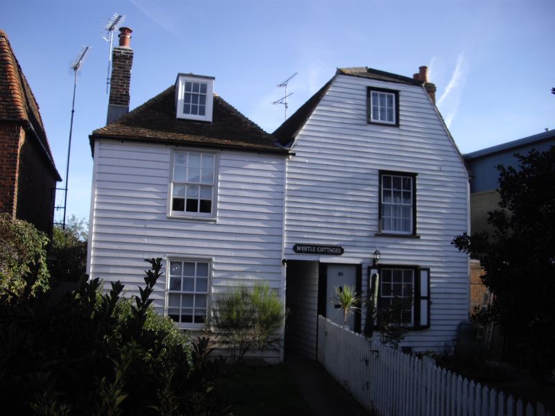
1.
5273
TR 1066 NE
1/17
23.12.75
HARBOUR STREET
(South-East Side)
Nos 50 and 51
II
GV
2.
Late C18 or early C19 buildings. 3 storeys. 1 window each lst floor. Fronted
with weatherboarding. Tiled roofs, No 50 with a half hip, No 51 hipped with dormer.
Glazing bars intact. Wooden shutters to ground flint windows. No 50 has a doorway
in moulded architrave surround with flat hood over. Passage through the ground
floor between the houses.
Listing NGR: TR1069766804
External links are from the relevant listing authority and, where applicable, Wikidata. Wikidata IDs may be related buildings as well as this specific building. If you want to add or update a link, you will need to do so by editing the Wikidata entry.


Other nearby listed buildings
