Approximate Location Map
Large Map »
Latitude: 51.2802 / 51°16'48"N
Longitude: 1.0795 / 1°4'46"E
OS Eastings: 614864
OS Northings: 157951
OS Grid: TR148579
Mapcode National: GBR TY2.PRK
Mapcode Global: VHLGM.N2KY
Plus Code: 9F3373JH+3R
Entry Name: 17, Best Lane
Listing Date: 3 May 1967
Grade: II
Source: Historic England
Source ID: 1085127
English Heritage Legacy ID: 170386
ID on this website: 101085127
Location: Canterbury, Kent, CT1
County: Kent
District: Canterbury
Electoral Ward/Division: Westgate
Parish: Non Civil Parish
Built-Up Area: Canterbury
Traditional County: Kent
Lieutenancy Area (Ceremonial County): Kent
Tagged with: Building
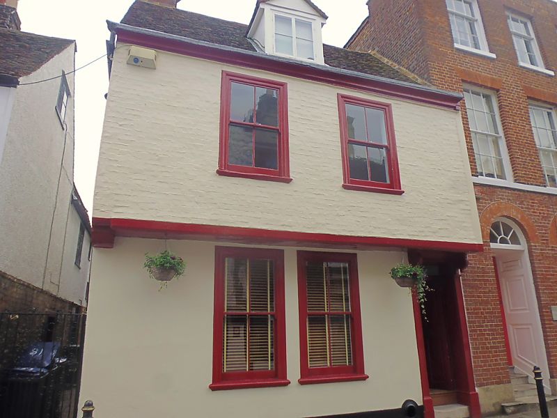
1.
944 BEST LANE
(South East Side)
No 17
TR 1457 NE 4/90 3.5.67.
II GV
2.
Probably timber-framed building refaced in C18. 2 storeys. Ground floor
stuccoed, first floor painted brick. Old tiled roof with 1 hipped dormer.
2 C19 sashes in moulded architraves. Overhang with C18 moulded bressumer.
Right side doorcase has a rectangular fanlight, 2 unusual console brackets,
pilasters and a 4 panelled door. Rear elevation of brick.
Nos 16A to 20 (consec), Nos 22 and 23 form a group.
Listing NGR: TR1486657949
External links are from the relevant listing authority and, where applicable, Wikidata. Wikidata IDs may be related buildings as well as this specific building. If you want to add or update a link, you will need to do so by editing the Wikidata entry.


Other nearby listed buildings
