Approximate Location Map
Large Map »
Latitude: 51.2819 / 51°16'54"N
Longitude: 1.0827 / 1°4'57"E
OS Eastings: 615080
OS Northings: 158156
OS Grid: TR150581
Mapcode National: GBR TY2.JKG
Mapcode Global: VHLGM.Q18L
Plus Code: 9F3373JM+Q3
Entry Name: 7, the Borough
Listing Date: 7 September 1973
Grade: II
Source: Historic England
Source ID: 1085137
English Heritage Legacy ID: 170400
ID on this website: 101085137
Location: Northgate, Canterbury, Kent, CT1
County: Kent
District: Canterbury
Electoral Ward/Division: Westgate
Parish: Non Civil Parish
Built-Up Area: Canterbury
Traditional County: Kent
Lieutenancy Area (Ceremonial County): Kent
Tagged with: Building
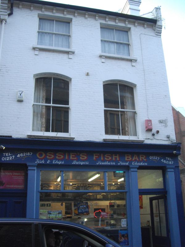
1.
944 THE BOROUGH
(South West Side)
No 7
TR 1558 SW 3/418
II GV
2.
Mid C19. 3 storeys painted brick. Bracket cornice. 2 sashes with verticals
only. First floor sashes have cambered heads. The Mid C19 shopfront has
4 plain pilasters and a cornice. Grade II for group value.
Nos 1 to 4 (consec) and Nos 7 to 21 (consec) form a group II group.
Also forms a group with Nos 72 to 74 (consec) and St Mary Northgate
Hall, Northgate.
Listing NGR: TR1507358159
External links are from the relevant listing authority and, where applicable, Wikidata. Wikidata IDs may be related buildings as well as this specific building. If you want to add or update a link, you will need to do so by editing the Wikidata entry.


Other nearby listed buildings
